Map At Position
In this guide you will learn how to find out which map (which may be of a region or country) contains a given (longitude, latitude) coordinate, also the size in bytes of that map, and whether it is already downloaded or not.
Find map containing specified coordinate
First, get an API key token, see the Getting Started guide.
Qt should be installed to continue.The Maps SDK for Qt should be installed, see the Setup Maps SDK for Qt guide.
Overview
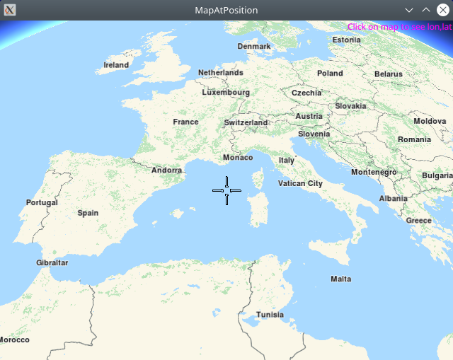
MapAtPosition demonstrates how easy it is to use MapView
to display an interactive map, and query the ContentStore with a
given (longitude, latitude) coordinate pair, to find out which map
contains that location.
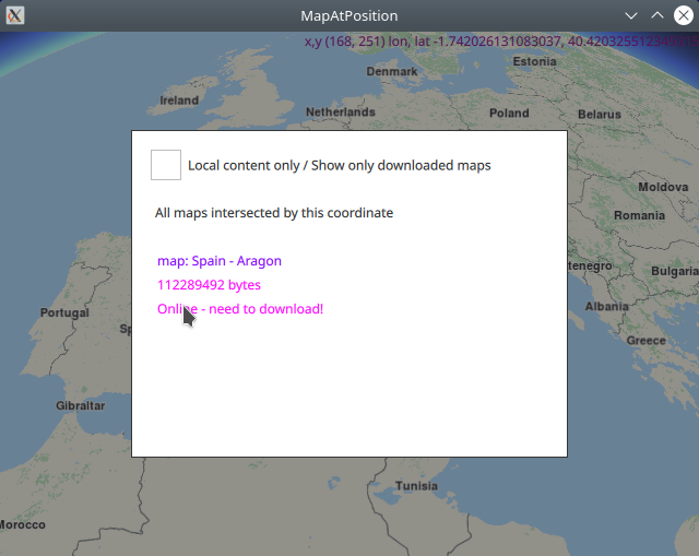
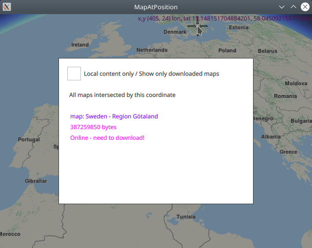
The resulting list of maps, usually 1, along with their sizes in bytes, containing the given coordinate, are displayed in a popup.
How it works
In Qt, go to the File menu and select Open File or Project…
then browse to the MapAtPosition example folder and open MapAtPosition.pro
You may want to have a look at Setting your API Key to see how to open and configure a project and set your API Key.
Map containing specified position
 1/////////////////////////////////////////////////////////////////////////////////
 2//display x,y pixel position and lon,lat coordinate of clicked position on map
 3//////////////////////////////////////////////////////////////////////////////////
 4TapHandler {
 5    grabPermissions: PointerHandler.CanTakeOverFromAnything
 6    onTapped: {
 7        let coordinates = map.wgsForScreen(point.pressPosition);
 8        console.log("x,y (" + point.pressPosition.x + ", " + point.pressPosition.y + ")"
 9                    + " lon, lat " + coordinates.longitude + ", " + coordinates.latitude);
10        lonlatPositionDisplay.text = "x,y (" + point.pressPosition.x + ", " + point.pressPosition.y + ")"
11                + " lon, lat " + coordinates.longitude + ", " + coordinates.latitude;
12        lonlatPositionDisplay.color = "#800080"
13        contentStore.intersectsCoordinate(coordinates.latitude, coordinates.longitude);
14        flag.gotCoord = true;
15    }
16}
The TapHandler block of code within the MapView block detects where the
user clicked on the map, and converts the x,y screen coordinates to longitude,latitude
coordinates on the globe using the wgsForScreen() function, and then queries the
online content store using the intersectsCoordinate() function, to find out which
map(s) contain the specified coordinate.
This is done using the intersectsCoordinate() function from the ContentStore
The result is received asynchronously via the onStatusChanged signal below.
A ContentStore instance which listens for the onStatusChanged signal
is defined, along with a connection to the online content store,
(which has maps, voices and styles), and the update() function is called
in the Component.onCompleted: block.
 1Component.onCompleted: {
 2    //! [Set token safely]
 3    ServicesManager.settings.token = __my_secret_token;
 4    //! [Set token safely]
 5
 6    ServicesManager.logLevel = ServicesManager.Error;
 7    ServicesManager.settings.allowInternetConnection = true; // enable connection to online services
 8
 9    updater.autoApplyWhenReady = true;
10    updater.update();
11}
12Connections {
13    target: updater
14    onFinished: {
15        if (result === GeneralMagic.Result.Ok || result === GeneralMagic.Result.UpToDate)
16            contentStore.update();
17        else
18            console.error("Content update failed");
19    }
20}
21ContentStore {
22    id: contentStore
23    type: ContentItem.Type.RoadMap //content.type
24    onStatusChanged: {
25        if ( flag.gotCoord )
26            intersectedMapsPopup.open()
27    }
28}
29Item {
30    id: flag
31    property bool gotCoord: false;
32}
A flag is also defined to indicate when a coordinate was selected interactively on the map by a user click, because the status change signal may occur for other reasons as well. The flag is initialized to false, set to true when the user clicks on the map to select a coordinate, and set to false again when the user clicks outside the popup showing the resulting list of map(s) containing the given coordinate, and thus the popup is closed.
When onStatusChanged signal is received, the content store internal map list
is populated with the results, which in this case is the list of maps (usually 1)
containing the specified coordinate. Note that this is a list of maps,
not necessarily of countries.
A map may contain an entire country, or only a part, or region, of a country.
Displaying the list of maps
The list of maps traversed by the given route is displayed in a popup and is scrollable. The size in bytes of each map is also shown, along with whether the map is already downloaded or not.
The popup uses the contentStore model to display the data populated in the
asynchronous reply. When the onStatusChanged signal is received, the popup
is invoked to show the results using the intersectedMapsPopup.open() function.
 1Popup {
 2    //////////////////////////////////////////////////////////////////////////////////
 3    //list of maps covering this coordinate shown in interactive popup - click outside to close;
 4    //////////////////////////////////////////////////////////////////////////////////
 5    id: intersectedMapsPopup
 6    modal: true
 7    focus: true
 8    closePolicy: Popup.CloseOnEscape | Popup.CloseOnPressOutside
 9    width: 400
10    height: 300
11    anchors.centerIn: parent
12    ColumnLayout {
13        anchors.fill: parent
14        anchors.top: parent.TopLeft
15        RowLayout {
16            Layout.fillWidth: true
17            CheckBox {
18                id: localMapsCheckBox
19                text: "Local content only / Show only downloaded maps"
20                onCheckedChanged: storeList.model.localContentOnly = checked
21            }
22        }
23        RowLayout {
24            spacing: 10
25            Layout.margins: 10
26            Label {
27                text: localMapsCheckBox.checked ? "Maps intersected by this coordinate, which are also downloaded"
28                                                : "All maps intersected by this coordinate"
29            }
30            Button {
31                visible: contentStore.status !== GeneralMagic.Result.Ok
32                text: "Update failed, refresh?"
33                onClicked: contentStore.update()
34            }
35        }
36        Item {
37            Layout.fillHeight: true
38            Layout.fillWidth: true
39            ColumnLayout {
40                anchors.fill: parent
41                ListView {
42                    id: storeList
43                    clip: true
44                    Layout.fillHeight: true
45                    Layout.fillWidth: true
46                    model: contentStore
47                    delegate:
48                        ItemDelegate {
49                        id: control
50                        width: storeList.width
51                        contentItem: RowLayout {
52                            id: resultmaprow
53                            ColumnLayout {
54                                Layout.fillHeight: true
55                                Layout.fillWidth: true
56                                Text {
57                                    font.pixelSize: 12
58                                    color: "#8000ff"
59                                    text: "map: " + modelData.name
60                                }
61                                Text {
62                                    font.pixelSize: 12
63                                    color: modelData.completed ? "#008080" : "#ff00ff"
64                                    text: modelData.totalSize + " bytes"
65                                }
66                                Text {
67                                    font.pixelSize: 12
68                                    color: modelData.completed ? "#008080" : "#ff00ff"
69                                    text: modelData.completed ? "Local / downloaded / ready"
70                                                              : "Online - need to download!"
71                                }
72                            }
73                            TapHandler {
74                                target: resultmaprow
75                                onTapped: {
76                                    intersectedMapsPopup.close()
77                                    flag.gotCoord = false;
78                                }
79                            }
80                        }
81                    }
82                }
83            }
84        }
85    }
86}
See the ContentDownload example to see how to download maps from the content store.