Map Selection
In this guide you will learn how to select an item on an interactive map, such as an alternate route, if a route computation resulted in two or more routes, or a POI (point of interest), such as a park, a cafe, a mountain or an archeological site.
Setup
First, get an API key token, see the Getting Started guide.
Download the Maps & Navigation SDK for Android archive fileDownload the MapSelection project archive file or clone the project with Git
See the Configure Android Example guide.
Run the example
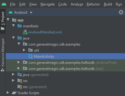
In Android Studio, from the File menu, select Sync Project with Gradle Files
An android device should be connected via USB cable.
Press SHIFT+F10 to compile, install and run the example on the
android device.
|
|
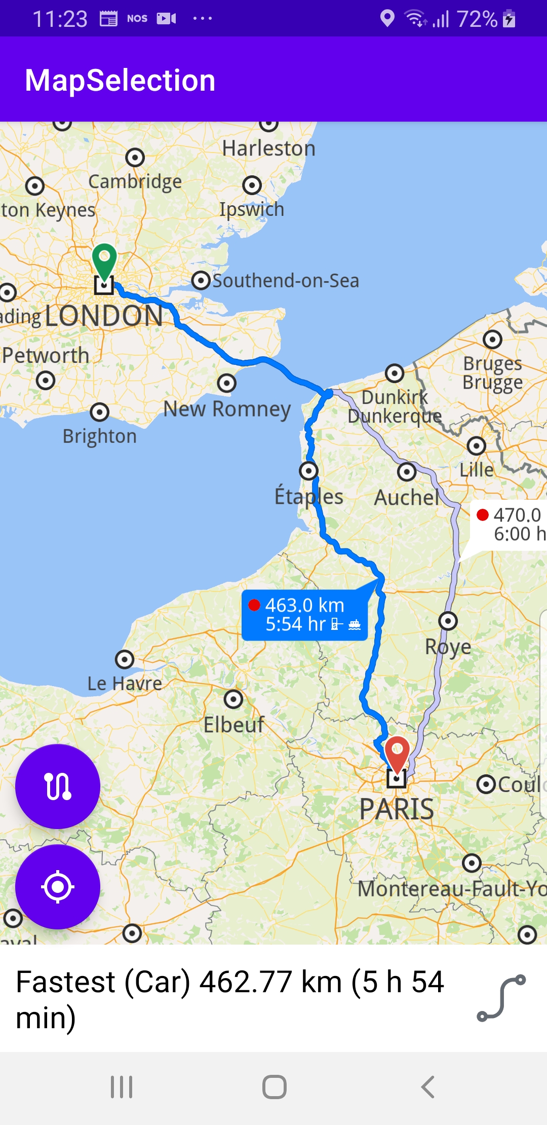
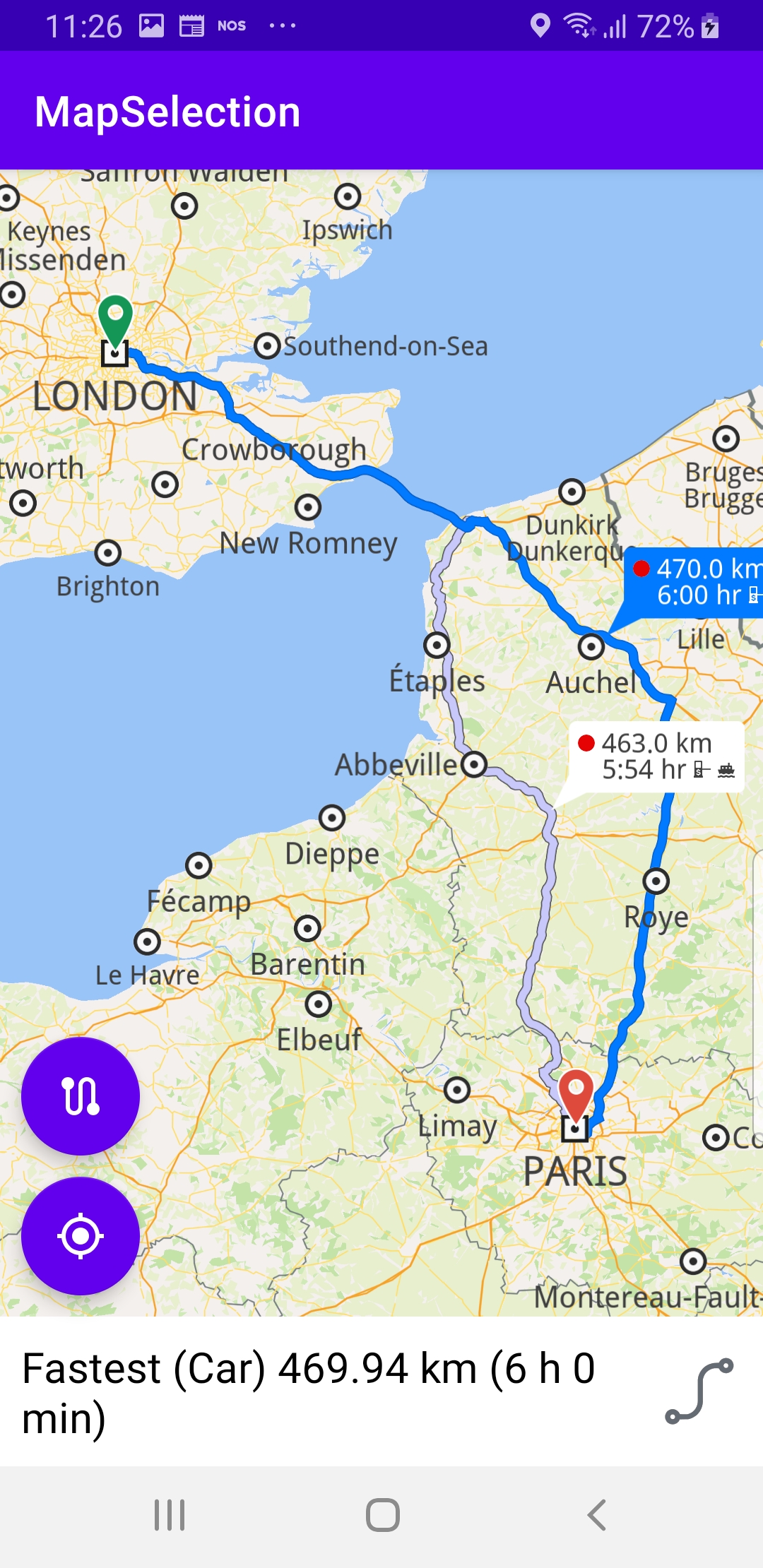
This example computes and draws a route on the map
and flies to it. The route has 2 alternatives, and
either can be selected by clicking the bubble next
to each route.
|
|
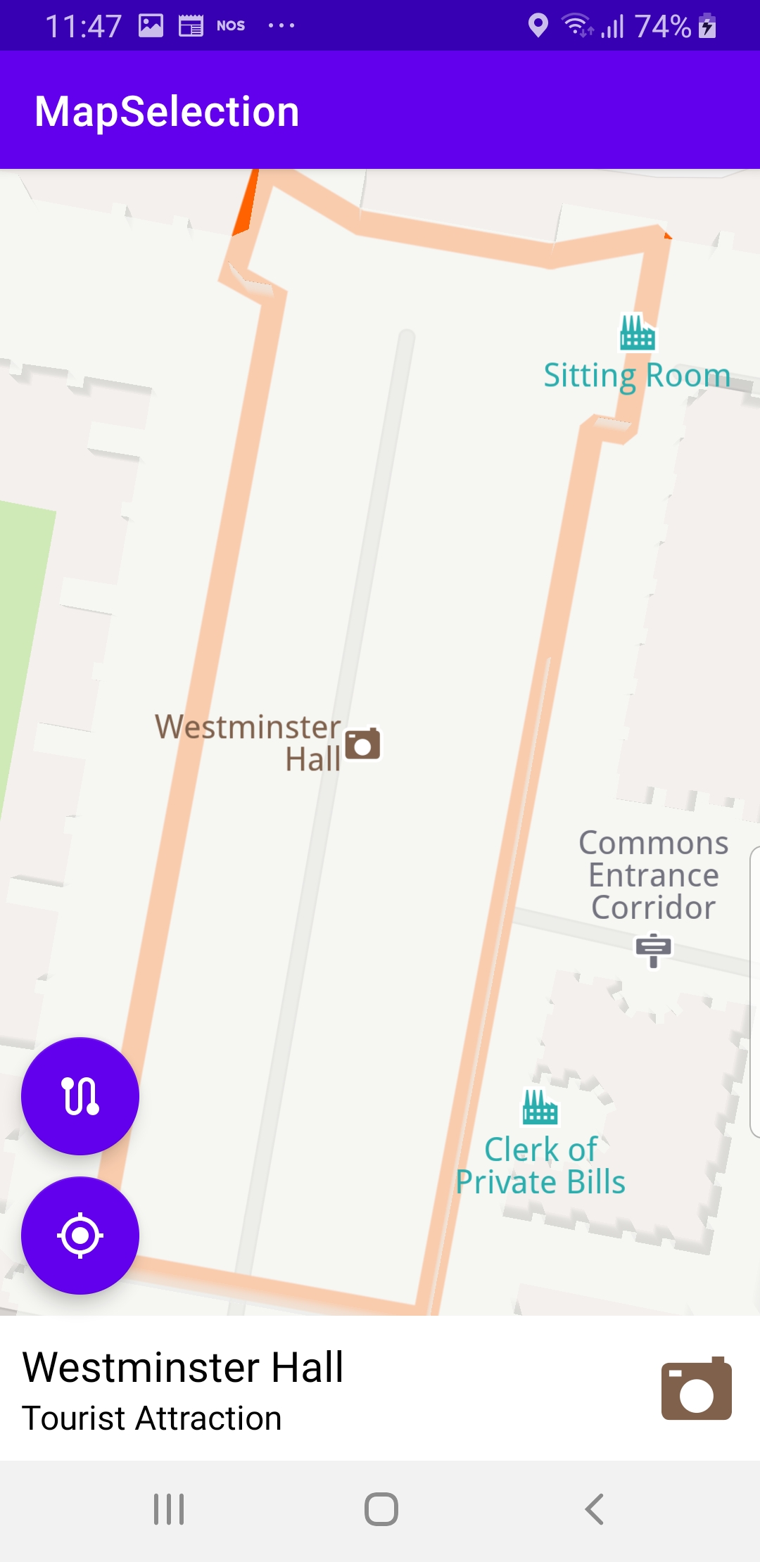
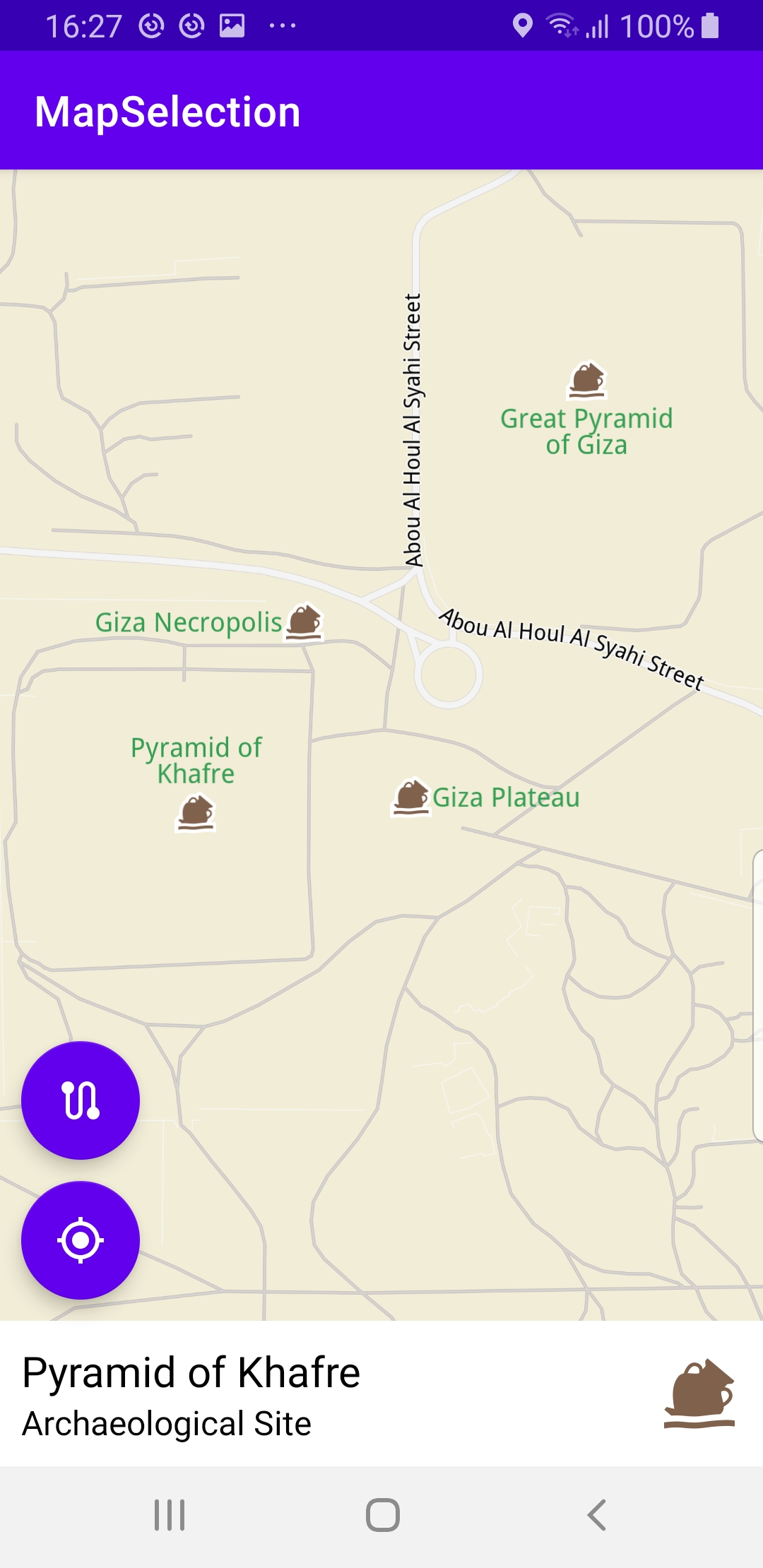
Displays an interactive map which is fully 3D,
supporting pan, pinch-zoom, rotate and tilt.
It is possible to zoom in and click on any POI
on the map to select it and fly to it.
How it works
You can open the MainActivity.kt file to see how the route is computed and drawn on the map.
1private fun calculateRoute() {
2  val waypoints = arrayListOf(
3    Landmark("London", Coordinates(51.5073204, -0.1276475)),
4    Landmark("Paris", Coordinates(48.8566932, 2.3514616))
5  )
6  routingService.calculateRoute(waypoints)
7}
In the
calculateRoute() function, 2 Landmark instances are
defined, one for the departure, and one for the destination
coordinates of the route endpoints. A route must have at least 2
Landmark instances(waypoints), but optionally can have more,
for any optional additional waypoints along the route.The starting, or departure point of the route is the first waypoint in a list of
2 or more Landmarks (2 in this case), each containing a name, latitude (in degrees)
and longitude (in degrees). The destination point is the last waypoint in the list.
In this example, the route departure point is London, and the destination is Paris,
as specified by the
Coordinates in the 2 Landmark instances.The list of waypoints is passed to the
routingService to calculate the route. 1private val routingService = RoutingService(
2 onStarted = {
3 progressBar.visibility = View.VISIBLE
4 },
5 onCompleted = { routes, errorCode, _ ->
6 progressBar.visibility = View.GONE
7 when (errorCode) {
8 GemError.NoError -> {
9 routesList = routes
10 SdkCall.execute {
11 gemSurfaceView.mapView?.presentRoutes(routes, displayBubble = true)
12 gemSurfaceView.mapView?.preferences?.routes?.mainRoute?.let { selectRoute(it) }
13 }
14 flyToRoutesButton.visibility = View.VISIBLE
15 }
16 GemError.Cancel -> {
17 // The routing action was cancelled.
18 }
19 else -> {
20 // There was a problem at computing the routing operation.
21 showDialog("Routing service error: ${GemError.getMessage(errorCode)}")
22 }
23 }
24 }
25)
A
RoutingService is instantiated to compute a route and render
it on the map. The onStarted and onCompleted callbacks are
implemented, to detect when the route computation is started and when
it is completed.When the route computation is completed, and there is no error,
the list of resulting routes is rendered on the map using
presentRoutes().The
displayBubble flag is set to true to show the distance in km,
and the time in hours, next to each route. 1override fun onCreate(savedInstanceState: Bundle?) {
2 super.onCreate(savedInstanceState)
3 setContentView(R.layout.activity_main)
4 progressBar = findViewById(R.id.progressBar)
5 gemSurfaceView = findViewById(R.id.gem_surface)
6 overlayContainer = findViewById(R.id.overlay_container)
7 name = findViewById(R.id.name)
8 description = findViewById(R.id.description)
9 image = findViewById(R.id.image)
10 followCursorButton = findViewById(R.id.follow_cursor)
11 flyToRoutesButton = findViewById<FloatingActionButton?>(R.id.fly_to_route).also {
12 it.setOnClickListener {
13 SdkCall.execute {
14 gemSurfaceView.mapView?.let { mapView ->
15 mapView.deactivateAllHighlights()
16 mapView.preferences?.routes?.mainRoute?.let { mainRoute ->
17 selectRoute(mainRoute)
18 }
19 }
20 }
21 }
22 }
23 imageSize = resources.getDimension(R.dimen.image_size).toInt()
24 SdkSettings.onMapDataReady = onMapDataReady@{ isReady ->
25 if (!isReady) return@onMapDataReady
26 // Defines an action that should be done when the world map is ready (Updated/ loaded).
27 calculateRoute()
28 // Set GPS button if location permission is granted, otherwise request permission
29 SdkCall.execute {
30 val hasLocationPermission = PermissionsHelper.hasPermission(this,
31 Manifest.permission.ACCESS_FINE_LOCATION)
32 if (hasLocationPermission)
33 {
34 Util.postOnMain { enableGPSButton() }
35 }
36 else
37 {
38 requestPermissions(this)
39 }
40 }
The
onCreate() function
calls the calculateRoute() function shown above,
once the map is ready, that is, instantiated and loaded.onCreate() also uses findViewById() to get pointers/handles
to each of the various graphical elements on which something is
rendered, or which are used for user input, such as the button in
the lower left to fly to the calculated routes, or the other button
to fly to the position of the device, also referred to as GPS position,
also appearing in the lower left of the viewport.The fly to GPS position button, which looks like a target,
accessed by
followCursorButton,
is shown only if the camera is not already following the position
of the device, indicated by a green arrow on the map.The center on routes button, with a stylized s-shaped serpentine
road section drawn on it, accessed by
flyToRoutesButton,
is used to fly back to the currently selected precalculated route,
after panning away from it for example;
this button is shown after the route is calculated and rendered. 1private fun requestPermissions(activity: Activity): Boolean
2{
3 val permissions = arrayListOf(
4 Manifest.permission.INTERNET,
5 Manifest.permission.ACCESS_NETWORK_STATE,
6 Manifest.permission.ACCESS_FINE_LOCATION,
7 Manifest.permission.ACCESS_COARSE_LOCATION
8 )
9 return PermissionsHelper.requestPermissions(
10 REQUEST_PERMISSIONS, activity, permissions.toTypedArray()
11 )
12}
The
requestPermissions() function asks the user for internet
and location permissions.The
onRequestPermissionsResult() function is overridden, to receive
the results of the permission requests. 1 // onTouch event callback
2 gemSurfaceView.mapView?.onTouch = { xy ->
3 // xy are the coordinates of the touch event
4 SdkCall.execute {
5 // tell the map view where the touch event happened
6 gemSurfaceView.mapView?.cursorScreenPosition = xy
7 gemSurfaceView.mapView?.deactivateAllHighlights()
8 val centerXy = Xy(gemSurfaceView.measuredWidth / 2, gemSurfaceView.measuredHeight / 2)
9 val myPosition = gemSurfaceView.mapView?.cursorSelectionSceneObject
10 if (myPosition != null
11 && isSameMapScene(myPosition, MapSceneObject.getDefPositionTracker().first!!))
12 {
13 showOverlayContainer(
14 GemUtil.getUIString(EStringIds.eStrMyPosition),
15 "",
16 GemUtilImages.asBitmap(ImageDatabase().getImageById(SdkImages.UI.SearchForCurrentLocation.value),
17 imageSize, imageSize)
18 )
19 myPosition.coordinates?.let {
20 gemSurfaceView.mapView?.centerOnCoordinates(
21 it,
22 -1,
23 centerXy,
24 Animation(EAnimation.Linear),
25 Double.MAX_VALUE,
26 0.0
27 )
28 }
29 return@execute
30 }
1
The
onTouch listener is defined for the mapView to get
the cursorScreenPosition. Once the x,y position of the user
touch event has been set in the mapView, the code verifies
what map element was selected.val myPosition = gemSurfaceView.mapView?.cursorSelectionSceneObjectFirst, check if it is a scene object, such as a 3D car or plane, etc,
simulated in the scene. If so,
myPosition.coordinates?.let {
get the coordinates of the scene object (it), and use thegemSurfaceView.mapView?.centerOnCoordinates(it, function to
move the camera with a flying animationAnimation(EAnimation.Linear),
to the selected object. 1 val landmarks = gemSurfaceView.mapView?.cursorSelectionLandmarks
2 if (!landmarks.isNullOrEmpty())
3 {
4 val landmark = landmarks[0]
5 landmark.run {
6 showOverlayContainer(
7 name.toString(),
8 description.toString(),
9 image?.asBitmap(imageSize, imageSize)
10 )
11 }
12 val contour = landmark.getContourGeographicArea()
13 if (contour != null && !contour.isEmpty())
14 {
15 contour.let {
16 gemSurfaceView.mapView?.centerOnArea(
17 it,
18 -1,
19 centerXy,
20 Animation(EAnimation.Linear),
21 )
22 val displaySettings = HighlightRenderSettings(
23 EHighlightOptions.ShowContour,
24 Rgba(255, 98, 0, 255),
25 Rgba(255, 98, 0, 255),
26 0.75
27 )
28 gemSurfaceView.mapView?.activateHighlightLandmarks(landmark, displaySettings)
29 }
30 }
31 else
32 {
33 landmark.coordinates?.let {
34 gemSurfaceView.mapView?.centerOnCoordinates(
35 it,
36 -1,
37 centerXy,
38 Animation(EAnimation.Linear),
39 Double.MAX_VALUE,
40 0.0
41 )
42 }
43 }
44 return@execute
45 }
1
val landmarks = gemSurfaceView.mapView?.cursorSelectionLandmarksNext, check if the selected object is a landmark.
val contour = landmark.getContourGeographicArea()If landmarks is not null, check if it is a geographic area,
(contour is also not null) and in that case, use the
gemSurfaceView.mapView?.centerOnArea(
function to move the camera with a flying animation to the
selected region, such that the bounding box of
the selected region fits snugly in the viewport.If contour is null, then this is a simple landmark,
so just get its coordinates and move the camera to the landmark
with a flying animation:
landmark.coordinates?.let { gemSurfaceView.mapView?.centerOnCoordinates(1 val trafficEvents = gemSurfaceView.mapView?.cursorSelectionTrafficEvents
2 if (!trafficEvents.isNullOrEmpty())
3 {
4 hideOverlayContainer()
5 openWebActivity(trafficEvents[0].previewUrl.toString())
6
7 return@execute
8 }
Also check if the selected object is a traffic event,
val trafficEvents = gemSurfaceView.mapView?.cursorSelectionTrafficEventsand if so, get the string description of the first one,
openWebActivity(trafficEvents[0].previewUrl.toString())
at index 0, in case there are more than one. 1 val overlays = gemSurfaceView.mapView?.cursorSelectionOverlayItems
2 if (!overlays.isNullOrEmpty())
3 {
4 val overlay = overlays[0]
5 if (overlay.overlayInfo?.uid == ECommonOverlayId.Safety.value)
6 {
7 hideOverlayContainer()
8 openWebActivity(overlay.getPreviewUrl(Size()).toString())
9 }
10 else
11 {
12 overlay.run {
13 showOverlayContainer(
14 name.toString(),
15 overlayInfo?.name.toString(),
16 image?.asBitmap(imageSize, imageSize)
17 )
18 }
19 overlay.coordinates?.let {
20 gemSurfaceView.mapView?.centerOnCoordinates(
21 it,
22 -1,
23 centerXy,
24 Animation(EAnimation.Linear),
25 Double.MAX_VALUE,
26 0.0
27 )
28 }
29 }
30 return@execute
31 }
Check if the selected object is an overlay,
val overlays = gemSurfaceView.mapView?.cursorSelectionOverlayItemsand in the usual case fly to its coordinates
overlay.coordinates?.let { gemSurfaceView.mapView?.centerOnCoordinates( 1 // get the visible routes at the touch event point
2 val routes = gemSurfaceView.mapView?.cursorSelectionRoutes
3 // check if there is any route
4 if (!routes.isNullOrEmpty())
5 {
6 // set the touched route as the main route and center on it
7 val route = routes[0]
8 selectRoute(route)
9
10 return@execute
11 }
12 }
13 }
14 }
Finally, get the visible routes at the touch event point,
val routes = gemSurfaceView.mapView?.cursorSelectionRoutes
and if there is any route under the cursor, get a list of routes
with the cursorSelectionRoutes function.If the resulting list of routes is not empty, then
the first route in this list, at index 0, is set as the main route,
and
selectRoute() is called on this route to center it
with an animated motion. 1private fun selectRoute(route: Route)
2{
3 gemSurfaceView.mapView?.apply {
4 route.apply {
5 showOverlayContainer(
6 summary.toString(),
7 "",
8 GemUtilImages.asBitmap(
9 ImageDatabase().getImageById(SdkImages.UI.RouteShape2.value),
10 imageSize,
11 imageSize
12 )
13 )
14 }
15 preferences?.routes?.mainRoute = route
16 }
17
18 gemSurfaceView.mapView?.centerOnRoutes(routesList)
19}
The
selectRoute() function uses centerOnRoutes()
to fly the camera with an animated motion to the set
of computed routes, if there are more than one in the result,
such that their bounding box fits in the viewport,
so that all alternate routes are visible.If a route is selected by the user then that route is set
as the
mainRoute in order to highlight that particular
route.Note that centering on a particular route with an
animated camera motion can also be done like this:
gemSurfaceView.mapView?.centerOnRoute(route) 1private fun showOverlayContainer(name: String,
2 description: String, image: Bitmap?) = Util.postOnMain {
3 if (!overlayContainer.isVisible)
4 {
5 overlayContainer.visibility = View.VISIBLE
6 }
7 this.name.text = name
8 if (description.isNotEmpty())
9 {
10 this.description.apply {
11 text = description
12 visibility = View.VISIBLE
13 }
14 }
15 else
16 {
17 this.description.visibility = View.GONE
18 }
19 this.image.setImageBitmap(image)
20}
The
showOverlayContainer() function is used to
show for example the outline of the selected building,
or park, or the border of the selected country, etc.1 SdkSettings.onApiTokenRejected = {
2 showDialog("TOKEN REJECTED")
3 }
4 if (!Util.isInternetConnected(this))
5 {
6 showDialog("You must be connected to the internet!")
7 }
8}
The
onCreate() function also checks if internet access is available
and if not, shows a dialog that internet connection is required
(because it is used to download map data).