Route On Map
In this guide you will learn how to compute a route
between a departure and destination, and render the
route on an interactive map, supporting pan and zoom.
The map will be centered on the route such that the
route fits in the viewport.
Prerequisites
It is required that you complete the
Environment Setup - CPP Examples guide
as well as the
Create a Project - CPP Examples guide
and the
Interactive Map guide
before starting this guide.
Compute a route
Open the file CenterMap.cpp and add the following include.
1#include <API/GEM_RoutingService.h>
Comment out or delete the following line, which flies the camera to the specified latitude, longitude coordinates.
1//mapView->centerOnCoordinates({ 37.768741, -122.482696 }, 60);
Add the code below instead of the line above.
 1gem::RouteList routes;
 2{
 3   ProgressListener calculateRouteListener;
 4   gem::LandmarkList waypoints;
 5   waypoints.push_back(gem::Landmark("San Francisco", { 37.77903, -122.41991 }));
 6   waypoints.push_back(gem::Landmark("San Jose", { 37.33619, -121.89058 }));
 7   gem::RoutePreferences preferences;
 8   gem::RoutingService().calculateRoute(routes, waypoints, preferences, &calculateRouteListener);
 9   auto ret = WAIT_UNTIL(std::bind(&ProgressListener::IsFinished, &calculateRouteListener), 15000);
10}
11if (routes.size() > 0)
12{
13   mapView->preferences().routes().add(routes[0], true);
14   mapView->centerOnRoute(routes[0], gem::Rect(), gem::Animation(gem::AnimationLinear, gem::ProgressListener(), 3000));
15}
This defines a
LandmarkList containing at least 2 waypoints, where the first
one is the departure point and the last one is the destination.Each waypoint has a name string, a latitude, in degrees, and a longitude, in degrees.
Next,
gem::RoutingService().calculateRoute() is used to compute the route
and wait for the results.The route computation results are stored in
gem::RouteList routes;
There could be 0 or more resulting routes between the specified departure
and destination. If there is at least one route, that is,if (routes.size() > 0) then the first route (at index 0) is selected and
added to the mapView. Then,
mapView->centerOnRoute() is used to fly the camera to the route, such that
the bounding box containing the route fits in the viewport.Try it out!
|
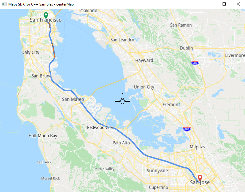
Click the green arrow play button at the top to compile and run the project. After the route is computed and rendered on the map, you can pan the map and zoom in/out using the mouse scroll wheel.