Areas alarms
This example demonstrates how to build a Flutter app using the Maps SDK which notifies the user when he enters or exits a geographic area. It can be used with any type of area that implements the GeographicArea interface.
How It Works
The example app highlights the following features:
- Display a map with a round polygon marker.
- Calculate route.
- Display route.
- Start simulation.
- Alarm service usage with area monitoring.
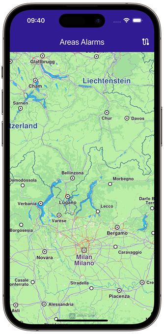 | 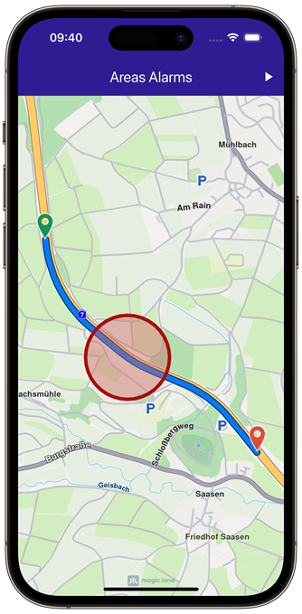 | 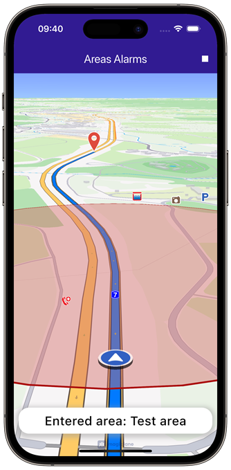 |
|---|---|---|
| Initial map | Area displayed on map | Enterned monitored area |
UI and Map Integration
The following code builds the UI with a GemMap widget and an app bar that includes buttons for calculating and simulating navigation on route as well as canceling the navigation. Once the position tracker enters or exits the CircleGeographicArea a bottom notification panel will be displayed.
const projectApiToken = String.fromEnvironment('GEM_TOKEN');
void main() {
runApp(const MyApp());
}
class MyApp extends StatelessWidget {
const MyApp({super.key});
Widget build(BuildContext context) {
return const MaterialApp(
debugShowCheckedModeBanner: false,
title: 'Areas Alarms',
home: MyHomePage(),
);
}
}
class MyHomePage extends StatefulWidget {
const MyHomePage({super.key});
State<MyHomePage> createState() => _MyHomePageState();
}
class _MyHomePageState extends State<MyHomePage> {
late GemMapController _mapController;
bool _areRoutesBuilt = false;
bool _isSimulationActive = false;
// We use the progress listener to cancel the route calculation.
TaskHandler? _routingHandler;
TaskHandler? _navigationHandler;
AlarmService? _alarmService;
AlarmListener? _alarmListener;
String? _areaNotification;
void dispose() {
GemKit.release();
super.dispose();
}
Widget build(BuildContext context) {
return Scaffold(
appBar: AppBar(
title: const Text(
"Areas Alarms",
style: TextStyle(color: Colors.white),
),
backgroundColor: Colors.deepPurple[900],
actions: [
if (!_isSimulationActive && _areRoutesBuilt)
IconButton(
onPressed: _startSimulation,
icon: const Icon(Icons.play_arrow, color: Colors.white),
),
if (_isSimulationActive)
IconButton(
onPressed: _stopSimulation,
icon: const Icon(Icons.stop, color: Colors.white),
),
if (!_areRoutesBuilt)
IconButton(
onPressed: () => _onBuildRouteButtonPressed(context),
icon: const Icon(Icons.route, color: Colors.white),
),
],
),
body: Stack(
children: [
GemMap(
key: ValueKey("GemMap"),
onMapCreated: _onMapCreated,
appAuthorization: projectApiToken,
),
if (_areaNotification != null)
Positioned(
bottom: MediaQuery.of(context).padding.bottom + 10,
left: 0,
child: BottomAlarmPanel(alarmNotification: _areaNotification),
),
],
),
resizeToAvoidBottomInset: false,
);
}
void _onMapCreated(GemMapController controller) {
_mapController = controller;
// Draw area on map
final marker = Marker();
final circleAreaCoords = generateCircleCoordinates(Coordinates(latitude: 50.92396, longitude: 9.54976), 200);
for (final coord in circleAreaCoords) {
marker.add(coord);
}
final markerCollection = MarkerCollection(markerType: MarkerType.polygon, name: "Circle");
markerCollection.add(marker);
_mapController.preferences.markers.add(markerCollection,
settings: MarkerCollectionRenderSettings(polygonFillColor: const Color.fromARGB(111, 210, 104, 102)));
}
// Custom method for calling calculate route and displaying the results.
void _onBuildRouteButtonPressed(BuildContext context) {
// Define the departure.
final departureLandmark = Landmark.withLatLng(
latitude: 50.92899490001731,
longitude: 9.544136681645025,
);
// Define the destination.
final destinationLandmark = Landmark.withLatLng(
latitude: 50.919902402432946,
longitude: 9.55855522546262,
);
// Define the route preferences.
final routePreferences = RoutePreferences();
_showSnackBar(context, message: 'The route is calculating.');
// Calling the calculateRoute SDK method.
// (err, results) - is a callback function that gets called when the route computing is finished.
// err is an error enum, results is a list of routes.
_routingHandler = RoutingService.calculateRoute(
[departureLandmark, destinationLandmark],
routePreferences,
(err, routes) async {
// If the route calculation is finished, we don't have a progress listener anymore.
_routingHandler = null;
ScaffoldMessenger.of(context).clearSnackBars();
// If there aren't any errors, we display the routes.
if (err == GemError.success) {
// Get the routes collection from map preferences.
final routesMap = _mapController.preferences.routes;
// Display the routes on map.
for (final route in routes) {
routesMap.add(route, route == routes.first);
}
// Center the camera on routes.
_mapController.centerOnRoutes(routes: routes);
}
setState(() {
_areRoutesBuilt = true;
});
},
);
}
// Method for starting the simulation and following the position,
void _startSimulation() {
final routes = _mapController.preferences.routes;
_mapController.preferences.routes.clearAllButMainRoute();
if (routes.mainRoute == null) {
_showSnackBar(context, message: "No main route available");
return;
}
// Registering callback for area corssing
_alarmListener = AlarmListener(
onBoundaryCrossed: (enteredAreas, exitedAreas) {
if (enteredAreas.isNotEmpty) {
setState(() {
_areaNotification = "Entered area: ${enteredAreas.first}";
});
} else {
setState(() {
_areaNotification = "Exited area: ${exitedAreas.first}";
});
}
},
);
// Set the alarms service with the listener
_alarmService = AlarmService(_alarmListener!);
_alarmService!.monitorArea(
CircleGeographicArea(radius: 200, centerCoordinates: Coordinates(latitude: 50.92396, longitude: 9.54976)),
id: "Test area");
_navigationHandler = NavigationService.startSimulation(
routes.mainRoute!,
null,
onNavigationInstruction: (instruction, events) {
setState(() {
_isSimulationActive = true;
});
},
onDestinationReached: (landmark) {
_stopSimulation();
_cancelRoute();
},
onError: (error) {
// If the navigation has ended or if and error occurred while navigating, remove routes and reset alarm notification.
setState(() {
_isSimulationActive = false;
_areaNotification = null;
_cancelRoute();
});
if (error != GemError.cancel) {
_stopSimulation();
}
return;
},
);
// Set the camera to follow position.
_mapController.startFollowingPosition();
}
// Method for removing the routes from display,
void _cancelRoute() {
// Remove the routes from map.
_mapController.preferences.routes.clear();
if (_routingHandler != null) {
// Cancel the navigation.
RoutingService.cancelRoute(_routingHandler!);
_routingHandler = null;
}
setState(() {
_areRoutesBuilt = false;
});
}
// Method to stop the simulation and remove the displayed routes,
void _stopSimulation() {
// Cancel the navigation.
NavigationService.cancelNavigation(_navigationHandler!);
_navigationHandler = null;
_areaNotification = null;
_cancelRoute();
setState(() => _isSimulationActive = false);
}
}
Bottom Alarm Panel
class BottomAlarmPanel extends StatelessWidget {
final String? alarmNotification;
const BottomAlarmPanel({
super.key,
required this.alarmNotification,
});
Widget build(BuildContext context) {
return Container(
decoration: BoxDecoration(
color: Colors.white,
borderRadius: const BorderRadius.all(Radius.circular(20)),
boxShadow: [
BoxShadow(
color: Colors.grey.withValues(alpha: 0.5),
spreadRadius: 5,
blurRadius: 7,
offset: const Offset(0, 3),
),
],
),
width: MediaQuery.of(context).size.width - 20,
height: 50,
margin: const EdgeInsets.symmetric(horizontal: 10),
padding: const EdgeInsets.symmetric(horizontal: 15),
child: Center(
child: Text(
alarmNotification!,
style: const TextStyle(
color: Colors.black,
fontSize: 24,
fontWeight: FontWeight.w500,
),
)),
);
}
}
Utility Functions
// Method to show message in case calculate route is not finished,
void _showSnackBar(
  BuildContext context, {
  required String message,
  Duration duration = const Duration(hours: 1),
}) {
  final snackBar = SnackBar(content: Text(message), duration: duration);
  ScaffoldMessenger.of(context).showSnackBar(snackBar);
}

// Method for generating coordinates in a circle shape
List<Coordinates> generateCircleCoordinates(
  Coordinates center,
  double radiusMeters, {
  int numberOfPoints = 36,
}) {
  const earthRadius = 6371000; // in meters
  final centerLatRad = center.latitude * pi / 180;
  final centerLonRad = center.longitude * pi / 180;
  final coordinates = <Coordinates>[];

  for (var i = 0; i < numberOfPoints; i++) {
    final angle = 2 * pi * i / numberOfPoints;
    final deltaLat = (radiusMeters / earthRadius) * cos(angle);
    final deltaLon = (radiusMeters / (earthRadius * cos(centerLatRad))) * sin(angle);
    final pointLat = (centerLatRad + deltaLat) * 180 / pi;
    final pointLon = (centerLonRad + deltaLon) * 180 / pi;
    coordinates.add(Coordinates(latitude: pointLat, longitude: pointLon));
  }

  return coordinates;
}