Marker Collection Display Icon 
Setup 
First, get an API key token, see the Getting Started guide.
Download the Maps & Navigation SDK for Android archive file
Download the
                MarkerCollectionDisplayIcon


                project
archive file or clone the project with Git
See the Configure Android Example guide.
Run the example 
In Android Studio, from the
File
menu, select
                Sync


                Project


                with


                Gradle


                Files
|
|
|||
How it works 
You can open the MainActivity.kt file to see how rendering icons on a map to indicate POIs works.
 1private fun getBitmap(drawableRes: Int): Bitmap? {
 2     val drawable = if (Build.VERSION.SDK_INT >= Build.VERSION_CODES.LOLLIPOP) {
 3         ResourcesCompat.getDrawable(resources, drawableRes, theme)
 4     } else {
 5         ContextCompat.getDrawable(this, drawableRes)
 6     }
 7     drawable ?: return null
 8     val canvas = Canvas()
 9     val bitmap = Bitmap.createBitmap(
10         drawable.intrinsicWidth,
11         drawable.intrinsicHeight,
12         Bitmap.Config.ARGB_8888
13     )
14     canvas.setBitmap(bitmap)
15     drawable.setBounds(0, 0, drawable.intrinsicWidth, drawable.intrinsicHeight)
16     drawable.draw(canvas)
17     return bitmap
18}
1private fun toPngByteArray(bmp: Bitmap): ByteArray {
2     val stream = ByteArrayOutputStream()
3     bmp.compress(Bitmap.CompressFormat.PNG, 100, stream)
4     val byteArray: ByteArray = stream.toByteArray()
5     bmp.recycle()
6     return byteArray
7}
1override fun onCreate(savedInstanceState: Bundle?) {
2 super.onCreate(savedInstanceState)
3 binding = ActivityMainBinding.inflate(layoutInflater)
4 setContentView(binding.root)
5 val mapSurface = binding.gemSurface
6 mapSurface.onDefaultMapViewCreated = { mapView ->
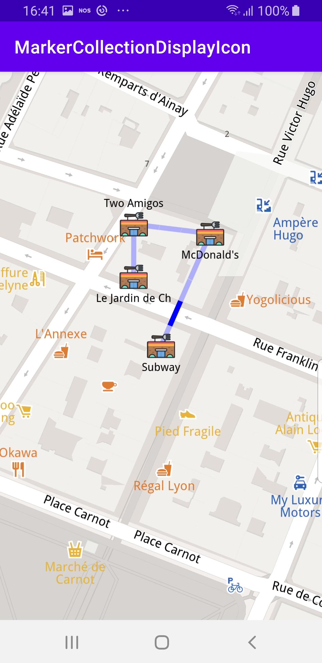
7 val predefinedPlaces = arrayListOf(
8 Pair("Subway", Coordinates(45.75242654325917, 4.828547972110576)),
9 Pair("McDonald's", Coordinates(45.75291679094701, 4.828855627148713)),
10 Pair("Two Amigos", Coordinates(45.75295718457783, 4.828377481057234)),
11 Pair("Le Jardin de Chine", Coordinates(45.75272771410631, 4.828376649181688)),
12 )
13 /* Image and text */
14 val imageTextsCollection = MarkerCollection(EMarkerType.Point, "Restaurants Nearby")
15 for (place in predefinedPlaces) {
16 Marker().apply {
17 setCoordinates(arrayListOf(place.second))
18 name = place.first
19 imageTextsCollection.add(this)
20 }
21 }
22 val image = getBitmap(R.drawable.ic_restaurant_foreground)?.let {
23 Image.produceWithDataBuffer(DataBuffer(toPngByteArray(it)), EImageFileFormat.Png)
24 }
25 val imageTextsSettings = MarkerCollectionRenderSettings(image)
26 imageTextsSettings.labelTextSize = 2.0 //mm
27 imageTextsSettings.labelingMode = EMarkerLabelingMode.Item
28 mapView.preferences?.markers?.add(imageTextsCollection, imageTextsSettings)
29 /* Polyline */
30 val polylineCollection = MarkerCollection(EMarkerType.Polyline, "Polyline")
31 Marker().apply {
32 for (place in predefinedPlaces)
33 add(place.second)
34 polylineCollection.add(this)
35 }
36 val polylineSettings = MarkerCollectionRenderSettings(polylineInnerColor = Rgba.blue())
37 polylineSettings.polylineInnerSize = 1.5 //mm
38 mapView.preferences?.markers?.add(polylineCollection, polylineSettings)
39 /* Center map on result */
40 mapView.centerOnCoordinates(predefinedPlaces[0].second, 80)
41 }
42 if (!Util.isInternetConnected(this)) {
43 Toast.makeText(this, "You must be connected to internet!", Toast.LENGTH_LONG).show()
44 }
45}
MainActivity
overrides the
onCreate()
function which checks that
internet access is available, and then, when the map is instantiated, defines
an array containing 4 POI (points of interest - restaurants in this case)
coordinate pairs - name, latitude, longitude:
                 mapSurface.onDefaultMapViewCreated


                 =


                 {


                 mapView


                 ->
                 val


                 predefinedPlaces


                 =


                 arrayListOf(
                 val


                 imageTextsCollection


                 =


                 MarkerCollection(EMarkerType.Point,


                 "Restaurants


                 Nearby")
                 for


                 (place


                 in


                 predefinedPlaces)


                 {
                 val


                 polylineCollection


                 =


                 MarkerCollection(EMarkerType.Polyline,


                 "Polyline")
                 Marker().apply


                 {
                 for


                 (place


                 in


                 predefinedPlaces)
                 val


                 polylineSettings


                 =


                 MarkerCollectionRenderSettings(polylineInnerColor


                 =


                 Rgba.blue())
                 polylineSettings.polylineInnerSize


                 =


                 1.5


                 //mm
                 mapView.centerOnCoordinates(predefinedPlaces[0].second,


                 80)