What Is Nearby Category
This example demonstrates how to create a Flutter app that shows nearby landmarks based on the user’s current position using the Maps SDK for Flutter.
How It Works
This example app demonstrates the following features:
- Display a
GemMap. - Get current position.
- Perform a search for nearby landmarks (gas stations category).
- Display search results.
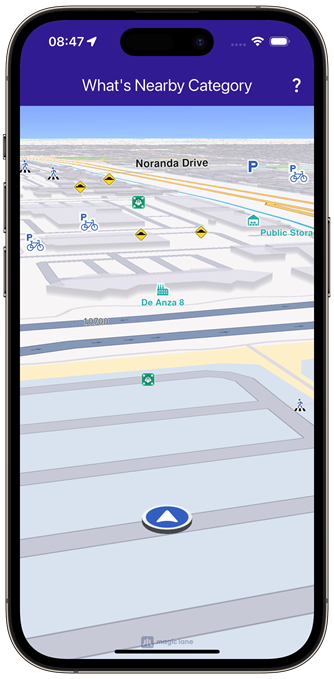 | 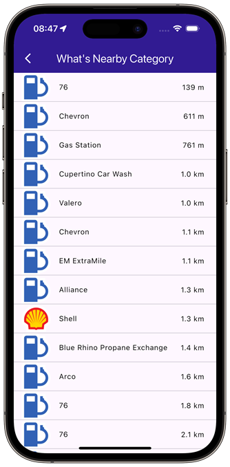 |
|---|---|
| Current position available | Nearby gas stations |
UI and Map Integration
The following code builds an UI with an interactive GemMap, an app bar with a button for navigating to search results page.
const projectApiToken = String.fromEnvironment('GEM_TOKEN');
void main() {
runApp(const MyApp());
}
class MyApp extends StatelessWidget {
const MyApp({super.key});
Widget build(BuildContext context) {
return const MaterialApp(
title: 'What\'s Nearby Category',
debugShowCheckedModeBanner: false,
home: MyHomePage(),
);
}
}
class MyHomePage extends StatefulWidget {
const MyHomePage({super.key});
State<MyHomePage> createState() => _MyHomePageState();
}
class _MyHomePageState extends State<MyHomePage> {
late GemMapController _mapController;
PermissionStatus _locationPermissionStatus = PermissionStatus.denied;
bool _hasLiveDataSource = false;
void dispose() {
GemKit.release();
super.dispose();
}
Widget build(BuildContext context) {
return Scaffold(
appBar: AppBar(
backgroundColor: Colors.deepPurple[900],
title: const Text(
'What\'s Nearby Category',
style: TextStyle(color: Colors.white),
),
actions: [
IconButton(
onPressed: () => _onWhatIsNearbyButtonPressed(context),
icon: const Icon(Icons.question_mark, color: Colors.white),
),
],
),
body: GemMap(
key: ValueKey("GemMap"),
onMapCreated: _onMapCreated,
appAuthorization: projectApiToken,
),
);
}
// The callback for when map is ready to use.
void _onMapCreated(GemMapController controller) async {
// Save controller for further usage.
_mapController = controller;
if (kIsWeb) {
// On web platform permission are handled differently than other platforms.
// The SDK handles the request of permission for location.
final locationPermissionWeb =
await PositionService.requestLocationPermission;
if (locationPermissionWeb == true) {
_locationPermissionStatus = PermissionStatus.granted;
} else {
_locationPermissionStatus = PermissionStatus.denied;
}
} else {
// For Android & iOS platforms, permission_handler package is used to ask for permissions.
_locationPermissionStatus = await Permission.locationWhenInUse.request();
}
if (_locationPermissionStatus == PermissionStatus.granted) {
// After the permission was granted, we can set the live data source (in most cases the GPS).
// The data source should be set only once, otherwise we'll get -5 error.
if (!_hasLiveDataSource) {
PositionService.instance.setLiveDataSource();
_hasLiveDataSource = true;
}
// Optionally, we can set an animation
final animation = GemAnimation(type: AnimationType.linear);
// Calling the start following position SDK method.
_mapController.startFollowingPosition(animation: animation);
}
}
void _onWhatIsNearbyButtonPressed(BuildContext context) {
// Get the current position with no altitude
final currentPosition = PositionService.instance.position;
if (currentPosition == null) {
ScaffoldMessenger.of(context).showSnackBar(
const SnackBar(content: Text('No position currently available')),
);
return;
}
final currentPositionNoAltitude = Coordinates(
latitude: currentPosition.latitude,
longitude: currentPosition.longitude,
altitude: 0.0,
);
// Pass the current position
Navigator.of(context).push(
MaterialPageRoute<dynamic>(
builder:
(context) =>
WhatIsNearbyCategoryPage(position: currentPositionNoAltitude),
),
);
}
}
Search Results Page
class WhatIsNearbyCategoryPage extends StatefulWidget {
final Coordinates position;
const WhatIsNearbyCategoryPage({super.key, required this.position});
State<WhatIsNearbyCategoryPage> createState() =>
_WhatIsNearbyCategoryPageState();
}
class _WhatIsNearbyCategoryPageState extends State<WhatIsNearbyCategoryPage> {
Widget build(BuildContext context) {
return Scaffold(
appBar: AppBar(
automaticallyImplyLeading: true,
foregroundColor: Colors.white,
title: const Text(
"What's Nearby Category",
style: TextStyle(color: Colors.white),
),
backgroundColor: Colors.deepPurple[900],
),
body: FutureBuilder(
future: _getNearbyLocations(),
builder: (context, snapshot) {
if (!snapshot.hasData || snapshot.data == null) {
return const Center(child: CircularProgressIndicator());
}
return ListView.separated(
itemBuilder: (context, index) {
return NearbyItem(
landmark: snapshot.data!.elementAt(index),
currentPosition: widget.position,
);
},
separatorBuilder:
(context, index) => const Divider(indent: 0, height: 0),
itemCount: snapshot.data!.length,
);
},
),
);
}
Future<List<Landmark>?> _getNearbyLocations() async {
// Add the gas stations category to SearchPreferences
final preferences = SearchPreferences(searchAddresses: false);
final genericCategories = GenericCategories.categories;
final gasStationCategory = genericCategories.firstWhere(
(category) => category.name == 'Gas Stations',
);
preferences.landmarks.addStoreCategoryId(
gasStationCategory.landmarkStoreId,
gasStationCategory.id,
);
final completer = Completer<List<Landmark>?>();
// Perform search around position with current position and preferences set with gas stations category
SearchService.searchAroundPosition(
preferences: preferences,
widget.position,
(err, result) {
completer.complete(result);
},
);
return completer.future;
}
}
class NearbyItem extends StatefulWidget {
final Landmark landmark;
final Coordinates currentPosition;
const NearbyItem({
super.key,
required this.landmark,
required this.currentPosition,
});
State<NearbyItem> createState() => _NearbyItemState();
}
class _NearbyItemState extends State<NearbyItem> {
Widget build(BuildContext context) {
return ListTile(
title: Text(
widget.landmark.name,
overflow: TextOverflow.fade,
style: const TextStyle(
color: Colors.black,
fontSize: 14,
fontWeight: FontWeight.w400,
),
maxLines: 2,
),
leading:
widget.landmark.img.isValid
? Image.memory(
widget.landmark.img.getRenderableImageBytes(
size: Size(128, 128),
)!,
)
: SizedBox(),
trailing: Text(
_convertDistance(
widget.landmark.coordinates.distance(widget.currentPosition).toInt(),
),
overflow: TextOverflow.fade,
style: const TextStyle(
color: Colors.black,
fontSize: 14,
fontWeight: FontWeight.w400,
),
),
);
}
String _convertDistance(int meters) {
if (meters >= 1000) {
double kilometers = meters / 1000;
return '${kilometers.toStringAsFixed(1)} km';
} else {
return '${meters.toString()} m';
}
}
}
Flutter Examples
Maps SDK for Flutter Examples can be downloaded or cloned with Git.