Search Location
In this guide, you will learn how to integrate map functionality and perform searches for landmarks using the Maps SDK for Flutter.
How It Works
This example demonstrates the following features:
- Search for landmarks around a specific location using latitude and longitude coordinates.
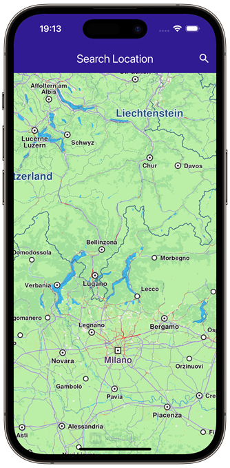 | 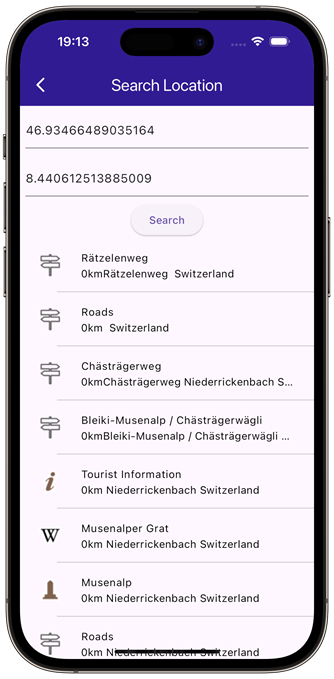 |
|---|---|
| Initial map view | Text search page |
Define state variables and methods
Within _MyHomePageState , define the necessary state variables and methods to manage the map and perform searches.
class _MyHomePageState extends State<MyHomePage> {
late GemMapController _mapController;
void _onMapCreated(GemMapController controller) {
_mapController = controller;
}
void dispose() {
GemKit.release();
super.dispose();
}
Widget build(BuildContext context) {
return Scaffold(
appBar: AppBar(
backgroundColor: Colors.deepPurple[900],
title: const Text("Search Location", style: TextStyle(color: Colors.white)),
actions: [
IconButton(
onPressed: () => _onSearchButtonPressed(context),
icon: const Icon(Icons.search, color: Colors.white),
),
],
),
body: GemMap(
key: ValueKey("GemMap"),
onMapCreated: _onMapCreated,
appAuthorization: projectApiToken,
),
);
}
void _onSearchButtonPressed(BuildContext context) async {
// Taking the coordinates at the center of the screen as reference coordinates for search.
final x = MediaQuery.of(context).size.width / 2;
final y = MediaQuery.of(context).size.height / 2;
final mapCoords = _mapController.transformScreenToWgs(XyType(x: x.toInt(), y: y.toInt()));
// Navigating to search screen. The result will be the selected search result (Landmark)
final result = await Navigator.of(context).push(MaterialPageRoute<dynamic>(
builder: (context) => SearchPage(coordinates: mapCoords!),
));
if (result is Landmark) {
// Activating the highlight
_mapController.activateHighlight([result], renderSettings: RenderSettings());
// Centering the map on the desired coordinates
_mapController.centerOnCoordinates(result.coordinates);
}
}
}
Define Search Functionality
Implement the SearchPage widget that allows users to search for landmarks.
class SearchPage extends StatefulWidget {
final Coordinates coordinates;
const SearchPage({super.key, required this.coordinates});
State<SearchPage> createState() => _SearchPageState();
}
class _SearchPageState extends State<SearchPage> {
List<Landmark> landmarks = [];
final TextEditingController _tecLatitude = TextEditingController();
final TextEditingController _tecLongitude = TextEditingController();
void initState() {
super.initState();
//Set initial coordinates the center of the map
_tecLatitude.text = widget.coordinates.latitude.toString();
_tecLongitude.text = widget.coordinates.longitude.toString();
}
Widget build(BuildContext context) {
return Scaffold(
appBar: AppBar(
automaticallyImplyLeading: true,
title: const Text("Search Location"),
backgroundColor: Colors.deepPurple[900],
foregroundColor: Colors.white,
),
body: Column(
children: [
Padding(
padding: const EdgeInsets.all(8.0),
child: TextField(
controller: _tecLatitude,
cursorColor: Colors.deepPurple[900],
decoration: const InputDecoration(
hintText: 'Latitude',
hintStyle: TextStyle(color: Colors.black),
focusedBorder: UnderlineInputBorder(
borderSide: BorderSide(color: Colors.deepPurple, width: 2.0),
),
),
),
),
Padding(
padding: const EdgeInsets.all(8.0),
child: TextField(
controller: _tecLongitude,
cursorColor: Colors.deepPurple[900],
decoration: const InputDecoration(
hintText: 'Longitude',
hintStyle: TextStyle(color: Colors.black),
focusedBorder: UnderlineInputBorder(
borderSide: BorderSide(color: Colors.deepPurple, width: 2.0),
),
),
),
),
ElevatedButton(
onPressed: _onSearchSubmitted,
child: const Text("Search"),
),
Expanded(
child: ListView.separated(
padding: EdgeInsets.zero,
itemCount: landmarks.length,
controller: ScrollController(),
separatorBuilder: (context, index) => const Divider(indent: 50, height: 0),
itemBuilder: (context, index) {
final lmk = landmarks.elementAt(index);
return SearchResultItem(landmark: lmk);
},
),
),
],
),
);
}
void _onSearchSubmitted() {
final latitude = double.tryParse(_tecLatitude.text);
final longitude = double.tryParse(_tecLongitude.text);
if (latitude == null || longitude == null) {
print("Invalid values for the reference coordinate.");
return;
}
Coordinates coords = Coordinates(latitude: latitude, longitude: longitude);
SearchPreferences preferences = SearchPreferences(
maxMatches: 40,
allowFuzzyResults: true,
);
search(coords, preferences: preferences);
}
late Completer<List<Landmark>> completer;
// Search method. Coordinates are mandatory, preferences are optional.
Future<void> search(
Coordinates coordinates, {
SearchPreferences? preferences,
}) async {
completer = Completer<List<Landmark>>();
// Calling the search around position SDK method.
// (err, results) - is a callback function that calls when the computing is done.
// err is an error code, results is a list of landmarks
SearchService.searchAroundPosition(coordinates, preferences: preferences, (
err,
results,
) async {
// If there is an error or there aren't any results, the method will return an empty list.
if (err != GemError.success) {
completer.complete([]);
return;
}
if (!completer.isCompleted) completer.complete(results);
});
final result = await completer.future;
setState(() {
landmarks = result;
});
}
}
Define Class for the Search Results
Implement the SearchResultItem widget to display search results.
class SearchResultItem extends StatefulWidget {
final Landmark landmark;
const SearchResultItem({super.key, required this.landmark});
State<SearchResultItem> createState() => _SearchResultItemState();
}
class _SearchResultItemState extends State<SearchResultItem> {
Widget build(BuildContext context) {
return ListTile(
onTap: () => Navigator.of(context).pop(widget.landmark),
leading: Container(
padding: const EdgeInsets.all(8),
width: 50,
child:
widget.landmark.getImage() != null
? Image.memory(widget.landmark.getImage()!)
: SizedBox(),
),
title: Text(
widget.landmark.name,
overflow: TextOverflow.fade,
style: const TextStyle(
color: Colors.black,
fontSize: 14,
fontWeight: FontWeight.w400,
),
maxLines: 2,
),
subtitle: Text(
widget.landmark.getFormattedDistance() + widget.landmark.getAddress(),
overflow: TextOverflow.ellipsis,
style: const TextStyle(
color: Colors.black,
fontSize: 14,
fontWeight: FontWeight.w400,
),
),
);
}
}
Define Extensions for Landmarks
Implement an extension to format the address and distance of landmarks.
extension LandmarkExtension on Landmark {
  String getAddress() {
    final addressInfo = address;
    final street = addressInfo.getField(AddressField.streetName);
    final city = addressInfo.getField(AddressField.city);
    final country = addressInfo.getField(AddressField.country);

    return '$street $city $country';
  }

  String getFormattedDistance() {
    String formattedDistance = '';

    double distance = (extraInfo.getByKey(PredefinedExtraInfoKey.gmSearchResultDistance) / 1000) as double;
    formattedDistance = "${distance.toStringAsFixed(0)}km";
    return formattedDistance;
  }
}
Flutter Examples
Maps SDK for Flutter Examples can be downloaded or cloned with Git.