Projections
- UIKit
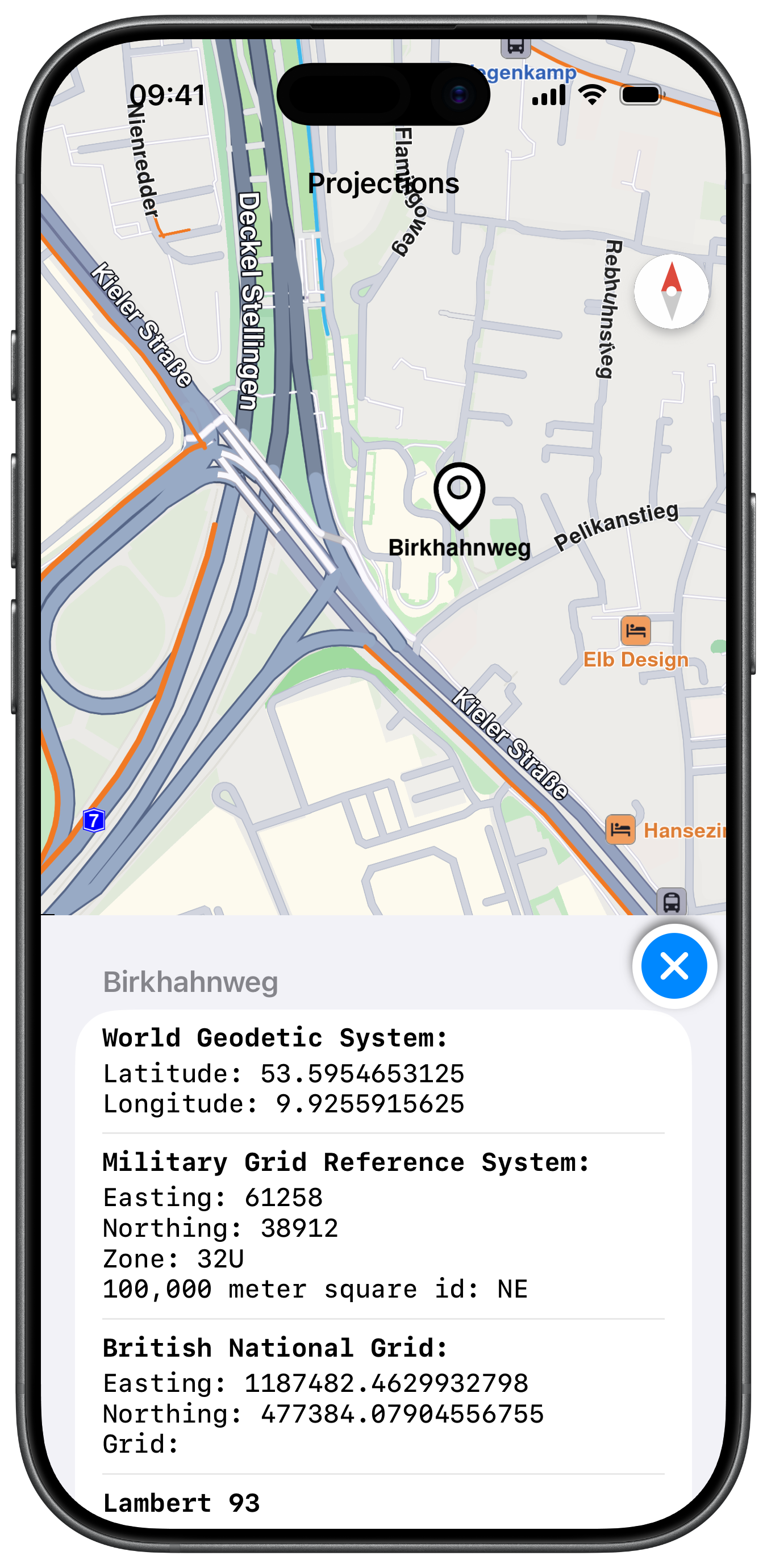
This example demonstrates how to use GEMKit in a UIKit application to convert the coordinates of a selected landmark to different projections and display the results in a table view.
Check the full implementation on GitHub.
Projections Table
Map Display and Projections Table View
The following code outlines the main view, which displays the map and prepares the table view to show the different projections for a selected landmark:
ViewController.swiftView on GitHub
class ItemProjection: NSObject {

    var title: NSAttributedString = NSAttributedString.init(string: "")
    var details: NSAttributedString = NSAttributedString.init(string: "")
    var object: ProjectionObject?
}

class ViewController: UIViewController, MapViewControllerDelegate, UITableViewDataSource, UITableViewDelegate {

    var mapViewController: MapViewController?
    var projectionContext: ProjectionContext?

    var tableView: UITableView?
    var buttonExit: UIButton?
    var modelData: [ItemProjection] = []
    var selectedLandmark: LandmarkObject?

    deinit {

        if let controller = mapViewController {

            controller.destroy()
        }
    }

    override func viewDidLoad() {

        super.viewDidLoad()

        if let navigationController = self.navigationController {

            let appearance = navigationController.navigationBar.standardAppearance

            navigationController.navigationBar.scrollEdgeAppearance = appearance
        }

        self.title = "Projections"

        self.projectionContext = ProjectionContext.init()

        self.createMapView()

        self.addTableView()
    }

    override func viewWillAppear(_ animated: Bool) {

        super.viewWillAppear(animated)

        self.mapViewController!.startRender()
    }

    override func viewDidAppear(_ animated: Bool) {

        super.viewDidAppear(animated)

        let location = CoordinatesObject.coordinates(withLatitude: 53.592590, longitude: 9.924337)  // Hamburg

        self.mapViewController!.center(onCoordinates: location, zoomLevel: 70, animationDuration: 0)
    }

    override func viewWillDisappear(_ animated: Bool) {

        super.viewWillDisappear(animated)

        self.mapViewController!.stopRender()
    }

    // MARK: - Map View

    func createMapView() {

        self.mapViewController = MapViewController.init()
        self.mapViewController!.delegate = self
        self.mapViewController!.view.backgroundColor = UIColor.systemBackground

        self.addChild(self.mapViewController!)
        self.view.addSubview(self.mapViewController!.view)
        self.mapViewController!.didMove(toParent: self)

        self.mapViewController!.view.translatesAutoresizingMaskIntoConstraints = false
        NSLayoutConstraint.activate([
            self.mapViewController!.view.topAnchor.constraint(equalTo: self.view.topAnchor, constant: 0),
            self.mapViewController!.view.leadingAnchor.constraint(equalTo: self.view.leadingAnchor, constant: 0),
            self.mapViewController!.view.bottomAnchor.constraint(equalTo: self.view.bottomAnchor, constant: -0),
            self.mapViewController!.view.trailingAnchor.constraint(equalTo: self.view.trailingAnchor, constant: -0)
        ])
    }

    // MARK: - TableView

    func addTableView() {

        self.tableView = UITableView.init(frame: self.view.frame, style: .insetGrouped)
        self.tableView!.isHidden = true
        self.tableView!.dataSource = self
        self.tableView!.delegate = self

        self.view.addSubview(self.tableView!)

        self.tableView!.translatesAutoresizingMaskIntoConstraints = false
        NSLayoutConstraint.activate([
            self.tableView!.leadingAnchor.constraint(equalTo: self.view.leadingAnchor),
            self.tableView!.trailingAnchor.constraint(equalTo: self.view.trailingAnchor),
            self.tableView!.bottomAnchor.constraint(equalTo: self.view.bottomAnchor),
            self.tableView!.heightAnchor.constraint(equalToConstant: 360)
        ])

        let size: CGFloat = 50

        let buttonExit = UIButton.init(type: .system)
        buttonExit.isHidden = true
        buttonExit.setImage(
            UIImage.init(systemName: "xmark.circle.fill", withConfiguration: UIImage.SymbolConfiguration(pointSize: 30, weight: .medium)),
            for: .normal)
        buttonExit.addTarget(self, action: #selector(closeTableView), for: .touchUpInside)
        buttonExit.layer.shadowColor = UIColor.darkGray.cgColor
        buttonExit.layer.shadowOpacity = 0.8
        buttonExit.backgroundColor = UIColor.systemBackground
        buttonExit.layer.cornerRadius = size / 2

        self.buttonExit = buttonExit

        self.view.addSubview(buttonExit)

        buttonExit.translatesAutoresizingMaskIntoConstraints = false

        NSLayoutConstraint.activate([
            buttonExit.trailingAnchor.constraint(equalTo: self.view.trailingAnchor, constant: -5),
            buttonExit.bottomAnchor.constraint(equalTo: self.tableView!.topAnchor, constant: size + 5),
            buttonExit.widthAnchor.constraint(equalToConstant: size),
            buttonExit.heightAnchor.constraint(equalToConstant: size)
        ])
    }

    // MARK: - MapViewControllerDelegate

    func mapViewController(_ mapViewController: MapViewController, didSelectLandmarks landmarks: [LandmarkObject], onTouch point: CGPoint) {

        guard let landmark = landmarks.first else { return }

        self.handleSelection(landmark: landmark)
    }

    func mapViewController(
        _ mapViewController: MapViewController, didSelectLandmarks landmarks: [LandmarkObject], onLongTouch point: CGPoint
    ) {

        guard let landmark = landmarks.first else { return }

        self.handleSelection(landmark: landmark)
    }

    func mapViewController(_ mapViewController: MapViewController, didSelectStreets streets: [LandmarkObject], onTouch point: CGPoint) {

        guard let landmark = streets.first else { return }

        self.handleSelection(landmark: landmark)
    }

    func mapViewController(_ mapViewController: MapViewController, didSelectStreets streets: [LandmarkObject], onLongTouch point: CGPoint) {

        guard let landmark = streets.first else { return }

        self.handleSelection(landmark: landmark)
    }

    // MARK: - UITableViewDataSource

    func numberOfSections(in tableView: UITableView) -> Int {

        return 1
    }

    func tableView(_ tableView: UITableView, numberOfRowsInSection section: Int) -> Int {

        let count = self.modelData.count

        return count
    }

    func tableView(_ tableView: UITableView, titleForHeaderInSection section: Int) -> String? {

        if let lmk = self.selectedLandmark {

            return lmk.getLandmarkName()
        }

        return ""
    }

    func tableView(_ tableView: UITableView, cellForRowAt indexPath: IndexPath) -> UITableViewCell {

        let identifier = "defaultCellId"

        var cell = tableView.dequeueReusableCell(withIdentifier: identifier)

        if cell == nil {

            cell = UITableViewCell.init(style: .subtitle, reuseIdentifier: identifier)

            cell!.textLabel!.numberOfLines = 0
            cell!.detailTextLabel!.numberOfLines = 0
        }

        let item = self.modelData[indexPath.row]

        cell!.textLabel?.attributedText = item.title
        cell!.detailTextLabel?.attributedText = item.details

        return cell!
    }

    // MARK: - UITableViewDelegate

    func tableView(_ tableView: UITableView, heightForRowAt indexPath: IndexPath) -> CGFloat {

        return UITableView.automaticDimension
    }

    func tableView(_ tableView: UITableView, didSelectRowAt indexPath: IndexPath) {

        tableView.deselectRow(at: indexPath, animated: true)
    }
Converting Coordinates to Different Projections
The following code outlines the main functions to handle the landmark selection, highlight it on the map, and convert its coordinates to different projections:
ViewController.swiftView on GitHub
    // MARK: - Utils

    func handleSelection(landmark: LandmarkObject) {

        self.modelData.removeAll()

        let attributesMessage = self.getStringAttributes()

        let coordinates = landmark.getCoordinates()

        if coordinates.isValid() {

            let details = NSAttributedString.init(
                string: "Latitude: \(coordinates.latitude)\nLongitude: \(coordinates.longitude)", attributes: attributesMessage)

            let item = ItemProjection.init()
            item.title = self.getString(title: "World Geodetic System:")
            item.details = details
            self.modelData.append(item)
        }

        self.convertFrom(coordinates: coordinates, toType: .mgrs) { error, details in

            let item = ItemProjection.init()
            item.title = self.getString(title: "Military Grid Reference System:")
            item.details = self.getString(title: "", description: "Not supported.")

            if error == .kNoError {

                item.details = details
            }

            self.modelData.append(item)
            self.tableView!.reloadData()
        }

        self.convertFrom(coordinates: coordinates, toType: .bng) { error, details in

            let item = ItemProjection.init()
            item.title = self.getString(title: "British National Grid:")
            item.details = self.getString(title: "", description: "Not supported.")

            if error == .kNoError {

                item.details = details
            }

            self.modelData.append(item)
            self.tableView!.reloadData()
        }

        self.convertFrom(coordinates: coordinates, toType: .lam) { error, details in

            let item = ItemProjection.init()
            item.title = self.getString(title: "Lambert 93")
            item.details = self.getString(title: "", description: "Not supported.")

            if error == .kNoError {

                item.details = details
            }

            self.modelData.append(item)
            self.tableView!.reloadData()
        }

        self.convertFrom(coordinates: coordinates, toType: .utm) { error, details in

            let item = ItemProjection.init()
            item.title = self.getString(title: "Universal Transverse Mercator:")
            item.details = self.getString(title: "", description: "Not supported.")

            if error == .kNoError {

                item.details = details
            }

            self.modelData.append(item)
            self.tableView!.reloadData()
        }

        self.convertFrom(coordinates: coordinates, toType: .gk) { error, details in

            let item = ItemProjection.init()
            item.title = self.getString(title: "Gauss-Krueger")
            item.details = self.getString(title: "", description: "Not supported.")

            if error == .kNoError {

                item.details = details
            }

            self.modelData.append(item)
            self.tableView!.reloadData()
        }

        self.convertFrom(coordinates: coordinates, toType: .W3W) { error, details in

            let item = ItemProjection.init()
            item.title = self.getString(title: "What 3 Words")
            item.details = self.getString(title: "", description: "Not supported.")

            if error == .kNoError {

                item.details = details
            }

            self.modelData.append(item)
            self.tableView!.reloadData()
        }

        // let text = landmark.getLandmarkName()
        // let scale = UIScreen.main.scale
        // let image = landmark.getLandmarkImage(CGSize.init(width: 40*scale, height: 40*scale))

        self.highlight(landmark: landmark)

        self.selectedLandmark = landmark

        self.tableView!.reloadData()
        self.tableView!.isHidden = false
        self.buttonExit!.isHidden = false
    }

    func highlight(landmark: LandmarkObject) {

        let settings = HighlightRenderSettings.init()
        settings.showPin = true
        settings.imageSize = 7

        if landmark.isContourGeograficAreaEmpty() == false {

            settings.options = Int32(
                HighlightOption.showLandmark.rawValue | HighlightOption.overlap.rawValue | HighlightOption.showContour.rawValue)
            settings.contourInnerColor = UIColor.white
            settings.contourOuterColor = UIColor.systemBlue
        }

        self.mapViewController!.presentHighlights([landmark], settings: settings, highlightId: 0)

        if self.selectedLandmark == nil {

            self.mapViewController!.center(onCoordinates: landmark.getCoordinates(), zoomLevel: 70, animationDuration: 400)
        }
    }

    func convertFrom(
        coordinates: CoordinatesObject, toType: ProjectionType,
        completionHandler: (@escaping (_ error: SDKErrorCode, _ details: NSAttributedString) -> Void)
    ) {

        guard let projectionContext = self.projectionContext else { return }

        let fromProj = ProjectionWGS84Object.init(coordinates: coordinates)

        var toProj: ProjectionObject?

        switch toType {

        case .bng:
            toProj = ProjectionBNGObject.init()

        case .lam:
            toProj = ProjectionLAMObject.init()

        case .utm:
            toProj = ProjectionUTMObject.init()

        case .mgrs:
            toProj = ProjectionMGRSObject.init()

        case .gk:
            toProj = ProjectionGKObject.init()

        case .W3W:
            //
            // Token is available at: https://developer.what3words.com
            //
            /* toProj = ProjectionW3WObject(token: "") */
            break

        default:
            completionHandler(SDKErrorCode.kNotSupported, NSMutableAttributedString.init())
        }

        if let toProj = toProj {

            let attributesMessage = self.getStringAttributes()

            projectionContext.convert(fromProj, to: toProj) { error in

                let details = NSMutableAttributedString.init()

                if error == .kNoError {

                    switch toProj.getType() {

                    case .bng:
                        if let toProj = toProj as? ProjectionBNGObject {

                            let easting = toProj.getEasting()
                            let northing = toProj.getNorthing()
                            let gridRef = toProj.getGridReference()

                            details.append(NSMutableAttributedString.init(string: "Easting: \(easting)", attributes: attributesMessage))
                            details.append(NSMutableAttributedString.init(string: "\nNorthing: \(northing)", attributes: attributesMessage))
                            details.append(NSMutableAttributedString.init(string: "\nGrid: \(gridRef)", attributes: attributesMessage))
                        }

                    case .lam:
                        if let toProj = toProj as? ProjectionLAMObject {

                            let x = toProj.getX()
                            let y = toProj.getY()

                            details.append(NSMutableAttributedString.init(string: "X: \(x)", attributes: attributesMessage))
                            details.append(NSMutableAttributedString.init(string: "\nY: \(y)", attributes: attributesMessage))
                        }

                    case .utm:
                        if let toProj = toProj as? ProjectionUTMObject {

                            let x = toProj.getX()
                            let y = toProj.getY()
                            let zone = toProj.getZone()
                            let hemisphere = toProj.getHemisphere() == .north ? "North" : "South"

                            details.append(NSMutableAttributedString.init(string: "X: \(x)", attributes: attributesMessage))
                            details.append(NSMutableAttributedString.init(string: "\nY: \(y)", attributes: attributesMessage))
                            details.append(NSMutableAttributedString.init(string: "\nZone: \(zone)", attributes: attributesMessage))
                            details.append(
                                NSMutableAttributedString.init(string: "\nHemisphere: \(hemisphere)", attributes: attributesMessage))
                        }

                    case .mgrs:
                        if let toProj = toProj as? ProjectionMGRSObject {

                            let easting = toProj.getEasting()
                            let northing = toProj.getNorthing()
                            let zone = toProj.getZone()
                            let letters = toProj.getSq100kIdentifier()

                            details.append(NSMutableAttributedString.init(string: "Easting: \(easting)", attributes: attributesMessage))
                            details.append(NSMutableAttributedString.init(string: "\nNorthing: \(northing)", attributes: attributesMessage))
                            details.append(NSMutableAttributedString.init(string: "\nZone: \(zone)", attributes: attributesMessage))
                            details.append(
                                NSMutableAttributedString.init(
                                    string: "\n100,000 meter square id: \(letters)", attributes: attributesMessage))
                        }

                    case .gk:
                        if let toProj = toProj as? ProjectionGKObject {

                            let easting = toProj.getEasting()
                            let northing = toProj.getNorthing()
                            let zone = toProj.getZone()

                            details.append(NSMutableAttributedString.init(string: "Easting: \(easting)", attributes: attributesMessage))
                            details.append(NSMutableAttributedString.init(string: "\nNorthing: \(northing)", attributes: attributesMessage))
                            details.append(NSMutableAttributedString.init(string: "\nZone: \(zone)", attributes: attributesMessage))
                        }

                    case .W3W:
                        if let toProj = toProj as? ProjectionW3WObject {

                            let words = toProj.getWords()

                            details.append(NSMutableAttributedString.init(string: "Words: \(words)", attributes: attributesMessage))
                        }

                    default:
                        break
                    }
                }

                completionHandler(error, details)
            }
        }
    }