# Get started with routing
Last updated:
November 2, 2026
\| 8 minutes read
This guide explains how to calculate routes, customize routing preferences, retrieve turn-by-turn instructions, and access detailed route information including terrain profiles and traffic events.
Here’s a quick overview of what you can do with routing:
* Calculate routes from a start point to a destination.
* Include intermediary waypoints for multi-stop routes.
* Compute range routes to determine areas reachable within a specific range.
* Plan routes over predefined tracks.
* Customize routes with preferences like route types, restrictions, and more.
* Retrieve maneuvers and turn-by-turn instructions.
* Access detailed route profiles for further analysis.
## Calculate routes[](#calculate-routes "Direct link to Calculate routes")
Calculate a navigable route between a start point and destination. The route can be used for navigation or simulation.
```dart
// Define the departure.
final departureLandmark =
Landmark.withLatLng(latitude: 48.85682, longitude: 2.34375);
// Define the destination.
final destinationLandmark =
Landmark.withLatLng(latitude: 50.84644, longitude: 4.34587);
// Define the route preferences (all default).
final routePreferences = RoutePreferences();
TaskHandler? taskHandler = RoutingService.calculateRoute(
[departureLandmark, destinationLandmark], routePreferences,
(err, routes) {
if (err == GemError.success) {
showSnackbar("Number of routes: ${routes.length}");
} else if (err == GemError.cancel) {
showSnackbar("Route computation canceled");
} else {
showSnackbar("Error: $err");
}
});
```
info
The `RoutingService.calculateRoute` method returns `null` only when the computation fails to initiate. In such cases, calling `RouteService.cancelRoute(taskHandler)` is not possible. Error details are delivered through the `onComplete` function.
The callback function's `err` parameter can return these values:
| Value | Significance |
| ----------------------------- | ----------------------------------------------------------------------------------------------------------------------------------------------------------------- |
| `GemError.success` | successfully completed |
| `GemError.cancel` | cancelled by the user |
| `GemError.waypointAccess` | couldn't be found with the current preferences |
| `GemError.connectionRequired` | if allowOnlineCalculation = false in the routing preferences and the calculation can't be done on the client side due to missing data |
| `GemError.expired` | calculation can't be done on client side due to missing necessary data and the client world map data version is no longer supported by the online routing service |
| `GemError.routeTooLong` | routing was executed on the online service and the operation took too much time to complete (usually more than 1 min, depending on the server overload state) |
| `GemError.invalidated` | the offline map data changed ( offline map downloaded, erased, updated ) during the calculation |
| `GemError.noMemory` | routing engine couldn't allocate the necessary memory for the calculation |
### Follow the calculation status[](#follow-the-calculation-status "Direct link to Follow the calculation status")
Pass the optional `onStatusChanged` callback to be notified whenever the calculation state changes, which is useful for reflecting progress in the UI while `onComplete` still delivers the final result:
```dart
TaskHandler? taskHandler = RoutingService.calculateRoute(
[departureLandmark, destinationLandmark], routePreferences,
(err, routes) {
// Final result
},
onStatusChanged: (RouteStatus status) {
showSnackbar("Route status: $status");
});
```
The `RouteStatus` enum defines these states:
| Enum Case | Description |
| --------------------------- | -------------------------------------------------------------------- |
| `uninitialized` | The routing service has not been initialized. |
| `calculating` | A route calculation is in progress. |
| `waitingInternetConnection` | Waiting for an internet connection to complete routing. |
| `ready` | Route calculation finished successfully and the result is available. |
| `error` | An error occurred during route calculation. |
info
Whether the engine emits a given state depends on how the calculation proceeds. Treat the callback as progress reporting and keep `onComplete` as the authoritative result: the error table above lists what it reports and under which conditions.
Cancel an ongoing route computation if needed:
```dart
RoutingService.cancelRoute(taskHandler);
```
When the route is canceled, the callback returns `err` = `GemError.cancel`.
## Retrieve time and distance information[](#retrieve-time-and-distance-information "Direct link to Retrieve time and distance information")
Access estimated time of arrival (ETA), distance, and traffic details for computed routes.
Get time and distance information using the `Route.getTimeDistance` method:
```dart
TimeDistance td = route.getTimeDistance(activePart: false);
final totalDistance = td.totalDistanceM;
// same with:
//final totalDistance = td.unrestrictedDistanceM + td.restrictedDistanceM;
final totalDuration = td.totalTimeS;
// same with:
//final totalDuration = td.unrestrictedTimeS + td.restrictedTimeS;
// by default activePart = true
TimeDistance remainTd = route.getTimeDistance(activePart: true);
final totalRemainDistance = remainTd.totalDistanceM;
final totalRemainDuration = remainTd.totalTimeS;
```
Set `activePart` to `false` to compute time and distance for the entire route, or `true` (default) for only the remaining portion.
**Unrestricted** refers to public property routes, while **restricted** refers to private property routes. Time is measured in seconds and distance in meters.
### Access traffic events[](#access-traffic-events "Direct link to Access traffic events")
Retrieve traffic event details for the route:
```dart
List trafficEvents = route.trafficEvents;
for (final event in trafficEvents) {
RouteTransportMode transportMode = event.affectedTransportModes;
String description = event.description;
TrafficEventClass eventClass = event.eventClass;
TrafficEventSeverity eventSeverity = event.eventSeverity;
Coordinates from = event.from;
Coordinates to = event.to;
bool isRoadBlock = event.isRoadblock;
}
```
See the [Traffic Events guide](/docs/flutter/guides/core/traffic-events.md) for detailed information.
## Display routes on the map[](#display-routes-on-the-map "Direct link to Display routes on the map")
Routes are not automatically displayed after calculation. Visualize routes on the map using the display methods.
Refer to the [display routes on maps](/docs/flutter/guides/maps/display-map-items/display-routes.md) guide for visualization and customization options.
## Get the Terrain Profile[](#get-the-terrain-profile "Direct link to Get the Terrain Profile")
When computing the route we can choose to also build the `TerrainProfile` for the route.
In order to do that `RoutePreferences` must specify we want to also generate the `BuildTerrainProfile`:
```dart
final routePreferences = RoutePreferences(
buildTerrainProfile: const BuildTerrainProfile(enable: true),
);
```
danger
Set `BuildTerrainProfile` with `enable` flag to true in the preferences for `calculateRoute` to retrieve terrain profile data.
Access elevation and terrain data from the profile:
```dart
RouteTerrainProfile? terrainProfile = route.terrainProfile;
if (terrainProfile != null) {
double minElevation = terrainProfile.minElevation;
double maxElevation = terrainProfile.maxElevation;
int minElevDist = terrainProfile.minElevationDistance;
int maxElevDist = terrainProfile.maxElevationDistance;
double totalUp = terrainProfile.totalUp;
double totalDown = terrainProfile.totalDown;
// elevation at 100m from the route start
double elevation = terrainProfile.getElevation(100);
for (final section in terrainProfile.roadTypeSections) {
RoadType roadType = section.type;
int startDistance = section.startDistanceM;
}
for (final section in terrainProfile.surfaceSections) {
SurfaceType surfaceType = section.type;
int startDistance = section.startDistanceM;
}
for (final section in terrainProfile.climbSections) {
Grade grade = section.grade;
double slope = section.slope;
int startDistanceM = section.startDistanceM;
int endDistanceM = section.endDistanceM;
}
List categs = [-16, -10, -7, -4, -1, 1, 4, 7, 10, 16];
List steepSections = terrainProfile.getSteepSections(categs);
for (final section in steepSections) {
int categ = section.categ;
int startDistanceM = section.startDistanceM;
}
}
```
**RoadType** values: `motorways`, `stateRoad`, `road`, `street`, `cycleway`, `path`, `singleTrack`.
**SurfaceType** values: `asphalt`, `paved`, `unpaved`, `unknown`.
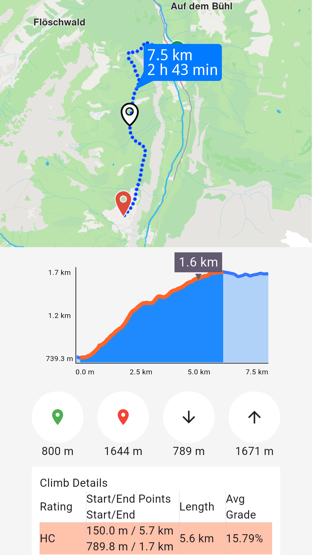
**Route profile chart**
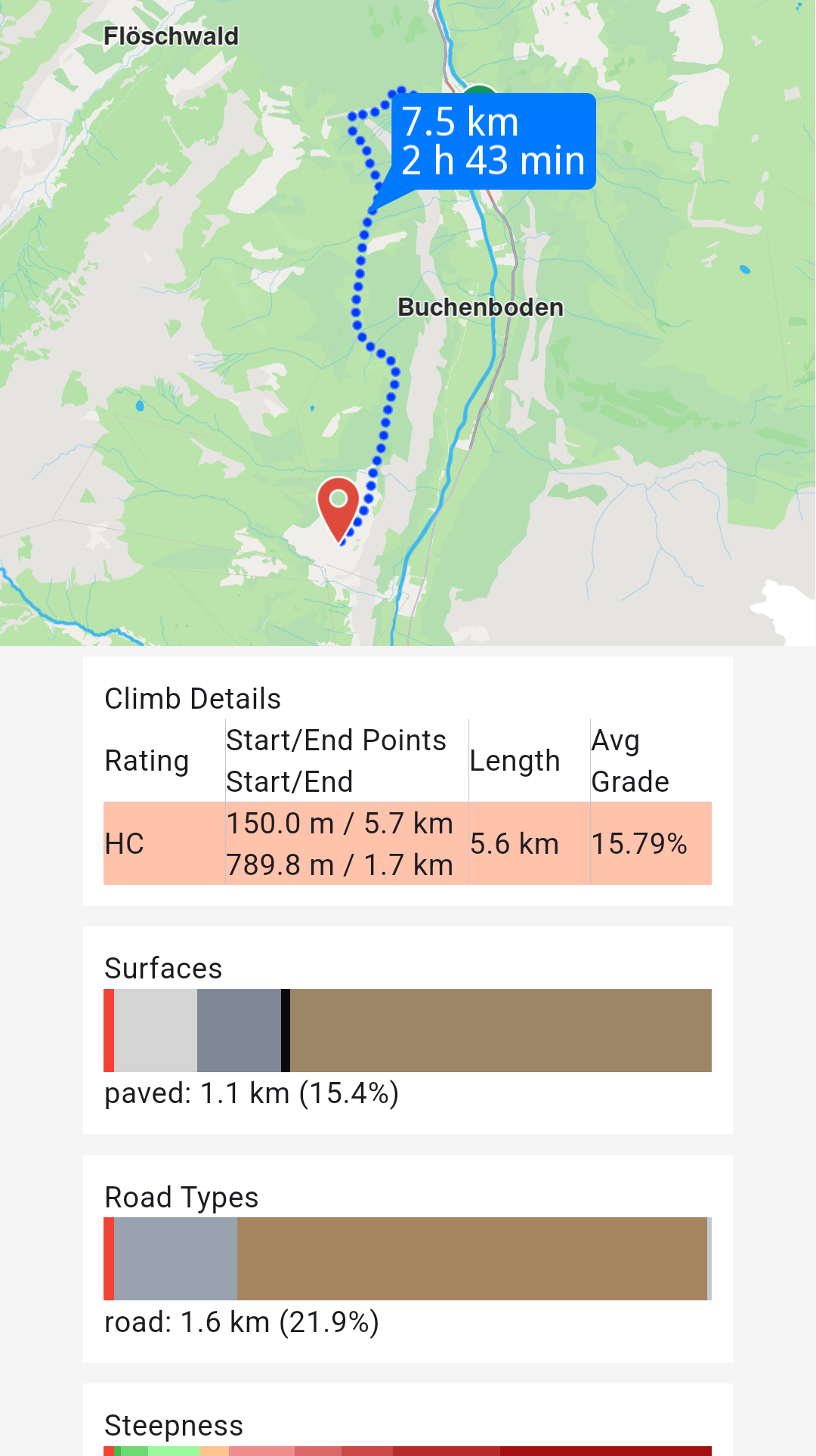
**Route profile sections**
See the [Route Profile example](/docs/flutter/examples/routing-navigation/route-profile.md) for detailed information.
## Retrieve route instructions[](#retrieve-route-instructions "Direct link to Retrieve route instructions")
Access detailed turn-by-turn instructions and segment information for computed routes.
Each **segment** represents the route portion between consecutive waypoints and includes its own set of instructions. A route with five waypoints contains four segments, each with distinct instructions.
For public transit routes, segments represent either pedestrian paths or transit sections.
Key **RouteInstruction** properties:
| Field | Type | Explanation |
| ---------------------------------- | ------------------- | ----------------------------------------------------------------------------------------------------------------- |
| traveledTimeDistance | TimeDistance | Time and distance from the beginning of the route. |
| remainingTravelTimeDistance | TimeDistance | Time and distance to the end of the route. |
| coordinates | Coordinates | The coordinates indicating the location of the instruction. |
| remainTravelTimeDistToNextWaypoint | TimeDistance | Time and distance until the next waypoint. |
| timeDistanceToNextTurn | TimeDistance | Time and distance until the next instruction. |
| turnDetails | TurnDetails | Get full details for the turn. |
| turnInstruction | String | Get textual description for the turn. |
| roadInfo | List\ | Get road information. |
| hasFollowRoadInfo | bool | Check is the road has follow road information. |
| followRoadInstruction | String | Get textual description for the follow road information. |
| countryCodeISO | String | Get ISO 3166-1 alpha-3 country code for the navigation instruction. |
| exitDetails | String | Get the exit route instruction text. |
| signpostInstruction | String | Get textual description for the signpost information. |
| signpostDetails | SignpostDetails | Get extended signpost details. |
| roadInfoImg | RoadInfoImg | Get customizable road image. The user is responsible to check if the image is valid. |
| turnImg | Img | Get turn image. The user is responsible to check if the image is valid. |
| realisticNextTurnImg | AbstractGeometryImg | Get customizable image for the realistic turn information. The user is resposible to check if the image is valid. |
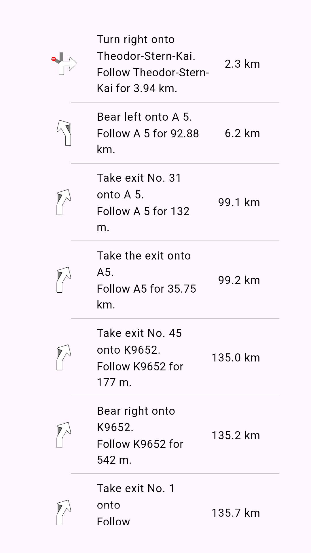
**List containing route instructions**
Access instruction data using these **RouteInstruction** methods:
* `turnInstruction`: Bear left onto A 5
* `followRoadInstruction`: Follow A 5 for 132m
* `traveledTimeDistance.totalDistanceM`: 6.2km (after formatting)
* `turnDetails.abstractGeometryImg.getRenderableImageBytes(renderSettings: AbstractGeometryImageRenderSettings(),size: Size(100, 100))`: Instruction image or null when invalid
## Relevant examples demonstrating routing related features[](#relevant-examples-demonstrating-routing-related-features "Direct link to Relevant examples demonstrating routing related features")
* [Calculate Route](/docs/flutter/examples/routing-navigation/calculate-route.md)
* [Route Profile](/docs/flutter/examples/routing-navigation/route-profile.md)
* [Route Instructions](/docs/flutter/examples/routing-navigation/route-instructions.md)
* [Finger Route](/docs/flutter/examples/routing-navigation/finger-route.md)
* [Range Finder](/docs/flutter/examples/routing-navigation/range-finder.md)
* [GPX Route](/docs/flutter/examples/routing-navigation/gpx-route.md)
* [Truck Profile](/docs/flutter/examples/routing-navigation/truck-profile.md)
* [Public Transit](/docs/flutter/examples/routing-navigation/public-transit.md)
* [Offline Routing](/docs/flutter/examples/routing-navigation/offline-routing.md)
* [Multi Map Routing](/docs/flutter/examples/routing-navigation/multimap-routing.md)
* [GPX Thumbnail Image](/docs/flutter/examples/routing-navigation/gpx-thumbnail-image.md)