Public Transit
This example demonstrates how to create a Flutter app that displays public transit routes using Maps SDK for Flutter. Users can calculate and visualize routes between two landmarks.
How it works
The example app demonstrates the following features:
- Display a map.
- Calculate a public transport route between two coordinates.
- Display computed route on map along with transit segments at the bottom of the screen.
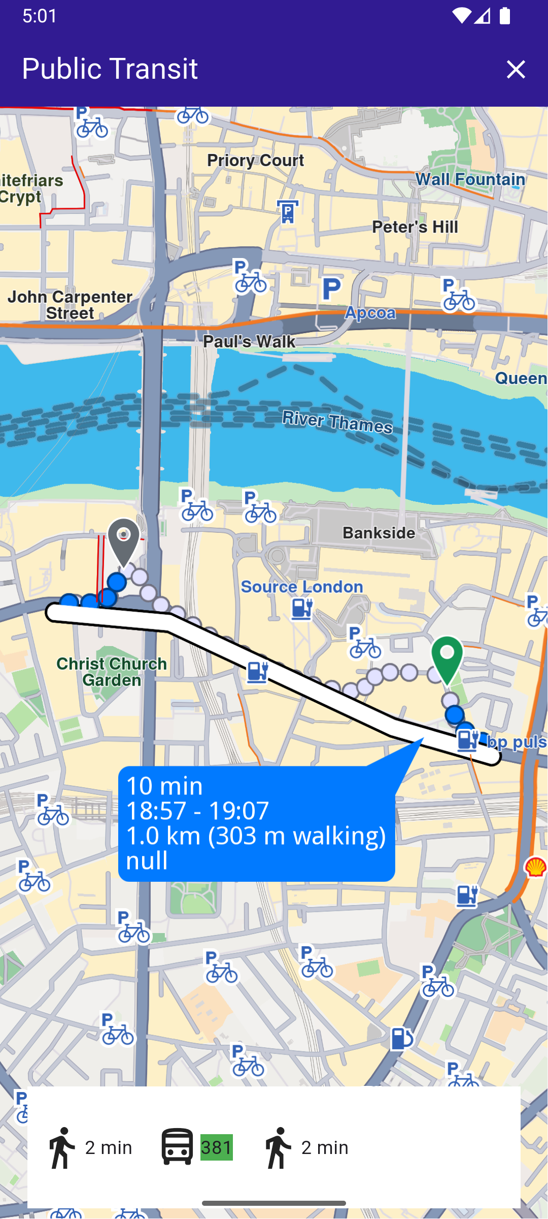
Public Transit Route
UI and Map Integration
This code sets up the main screen with a map and functionality for calculating and displaying public transit routes.
main.dartView on Github
void main() {
  runApp(const MyApp());
}

class MyApp extends StatelessWidget {
  const MyApp({super.key});

  @override
  Widget build(BuildContext context) {
    return const MaterialApp(
      debugShowCheckedModeBanner: false,
      title: 'Public Transit',
      home: MyHomePage(),
    );
  }
}

class MyHomePage extends StatefulWidget {
  const MyHomePage({super.key});

  @override
  State<MyHomePage> createState() => _MyHomePageState();
}

class _MyHomePageState extends State<MyHomePage> {
  late GemMapController _mapController;

  // We use the handler to cancel the route calculation.
  TaskHandler? _routingHandler;

  List<PTRouteSegment>? _ptSegments;

  @override
  void dispose() {
    GemKit.release();
    super.dispose();
  }

  @override
  Widget build(BuildContext context) {
    return Scaffold(
      appBar: AppBar(
        backgroundColor: Colors.deepPurple[900],
        title: const Text(
          'Public Transit',
          style: TextStyle(color: Colors.white),
        ),
        actions: [
          // Routes are not built.
          if (_routingHandler == null && _ptSegments == null)
            IconButton(
              onPressed: () => _onBuildRouteButtonPressed(context),
              icon: const Icon(Icons.route, color: Colors.white),
            ),
          // Routes calculating is in progress.
          if (_routingHandler != null)
            IconButton(
              onPressed: () => _onCancelRouteButtonPressed(),
              icon: const Icon(Icons.stop, color: Colors.white),
            ),
          // Routes calculating is finished.
          if (_ptSegments != null)
            IconButton(
              onPressed: () => _onClearRoutesButtonPressed(),
              icon: const Icon(Icons.clear, color: Colors.white),
            ),
        ],
      ),
      body: Stack(
        alignment: AlignmentDirectional.bottomCenter,
        children: [
          GemMap(
            key: ValueKey("GemMap"),
            onMapCreated: _onMapCreated,
            appAuthorization: projectApiToken,
          ),
          if (_ptSegments != null)
            Padding(
              padding: const EdgeInsets.all(8.0),
              child: Container(
                height: MediaQuery.of(context).size.height * 0.1,
                width: MediaQuery.of(context).size.width * 0.9,
                color: Colors.white,
                child: Row(
                  // Build a TransitSegment to display data from each segment
                  children: _ptSegments!.map((segment) {
                    return TransitSegment(segment: segment);
                  }).toList(),
                ),
              ),
            ),
        ],
      ),
    );
  }

  // The callback for when map is ready to use.
  Future<void> _onMapCreated(GemMapController controller) async {
    // Save controller for further usage.
    _mapController = controller;

    // Register route tap gesture callback.
    await _registerRouteTapCallback();
  }
Route Calculation
This code handles the route calculation and updates the UI with the calculated segments.
main.dartView on Github
  void _onBuildRouteButtonPressed(BuildContext context) {
    // Define the departure.
    final departureLandmark = Landmark.withLatLng(
      latitude: 51.505929,
      longitude: -0.097579,
    );

    // Define the destination.
    final destinationLandmark = Landmark.withLatLng(
      latitude: 51.507616,
      longitude: -0.105036,
    );

    // Define the route preferences with public transport mode.
    final routePreferences = RoutePreferences(
      transportMode: RouteTransportMode.public,
    );

    _showSnackBar(context, message: "The route is being calculated.");

    // Calling the calculateRoute SDK method.
    // (err, results) - is a callback function that gets called when the route computing is finished.
    // err is an error enum, results is a list of routes.

    _routingHandler = RoutingService.calculateRoute(
      [departureLandmark, destinationLandmark],
      routePreferences,
      (err, routes) {
        // If the route calculation is finished, we don't have a progress listener anymore.
        _routingHandler = null;
        ScaffoldMessenger.of(context).clearSnackBars();

        // If there aren't any errors, we display the routes.
        if (err == GemError.success) {
          // Get the routes collection from map preferences.
          final routesMap = _mapController.preferences.routes;

          // Display the routes on map.
          for (final route in routes) {
            routesMap.add(
              route,
              route == routes.first,
              label: route == routes.first ? getMapLabel(route) : null,
            );
          }

          // Center the camera on routes.
          _mapController.centerOnRoutes(routes: routes);
          // Convert normal route to PTRoute
          final ptRoute = routes.first.toPTRoute();
          // Convert each segment to PTRouteSegment
          final List<PTRouteSegment?> segments =
              ptRoute!.segments.map((seg) => seg.toPTRouteSegment()).toList();
          final List<PTRouteSegment> ptSegments = segments
              .where((seg) => seg != null)
              .cast<PTRouteSegment>()
              .toList();

          setState(() {
            _ptSegments = ptSegments;
          });
        }
      },
    );

    setState(() {});
  }
Transit Segment Display
This widget displays transit segments and relevant information about each route leg.
main.dartView on Github
class TransitSegment extends StatelessWidget {
  final PTRouteSegment segment;

  const TransitSegment({super.key, required this.segment});

  @override
  Widget build(BuildContext context) {
    return Padding(
      padding: const EdgeInsets.symmetric(horizontal: 8.0),
      child: segment.transitType == TransitType.walk
          ? Row(
              children: [
                const Icon(Icons.directions_walk, size: 35.0),
                Text(convertDistance(segment.timeDistance.totalDistanceM)),
              ],
            )
          : Row(
              children: [
                const Icon(Icons.directions_bus_outlined, size: 35.0),
                if (segment.hasWheelchairSupport)
                  const Icon(Icons.accessible_forward),
                Container(color: Colors.green, child: Text(segment.shortName)),
              ],
            ),
    );
  }
}
Utility Functions
These utility functions convert distances and durations into user-friendly formats.
utils.dartView on Github
String convertDistance(int meters) {
  if (meters >= 1000) {
    double kilometers = meters / 1000;
    return '${kilometers.toStringAsFixed(1)} km';
  } else {
    return '${meters.toString()} m';
  }
}

// Utility function to convert the seconds duration into a suitable format
String convertDuration(int seconds) {
  int hours = seconds ~/ 3600;
  int minutes = (seconds % 3600) ~/ 60;
  int remainingSeconds = seconds % 60;

  String hoursText = (hours > 0) ? '$hours h ' : '';
  String minutesText = (minutes > 0) ? '$minutes min ' : '';
  String secondsText =
      (hours == 0 && minutes == 0) ? '$remainingSeconds sec' : '';

  return (hoursText + minutesText + secondsText).trim();
Displaying Route Information
utils.dartView on Github
String getMapLabel(Route route) {
  // Get total distance and total duration from time distance.
  final totalDistance = route.getTimeDistance().unrestrictedDistanceM +
      route.getTimeDistance().restrictedDistanceM;
  final totalDuration = route.getTimeDistance().unrestrictedTimeS +
      route.getTimeDistance().restrictedTimeS;

  // Convert the route to a public transit route (PTRoute).
  final publicTransitRoute = route.toPTRoute();
  if (publicTransitRoute == null) {
    return "";
  }

  // Get the first and last segments of the route.
  final firstSegment = publicTransitRoute.segments.first.toPTRouteSegment();
  final lastSegment = publicTransitRoute.segments.last.toPTRouteSegment();

  if (firstSegment == null || lastSegment == null) {
    return "";
  }

  // Get departure and arrival times from the segments.
  final departureTime = firstSegment.departureTime;
  final arrivalTime = lastSegment.arrivalTime;

  // Calculate total walking distance (first and last segments are typically walking).
  final totalWalkingDistance = firstSegment.timeDistance.totalDistanceM +
      lastSegment.timeDistance.totalDistanceM;

  String formattedDepartureTime = "";
  String formattedArrivalTime = "";

  if (departureTime != null && arrivalTime != null) {
    // Format departure and arrival times.
    formattedDepartureTime =
        '${departureTime.hour}:${departureTime.minute.toString().padLeft(2, '0')}';
    formattedArrivalTime =
        '${arrivalTime.hour}:${arrivalTime.minute.toString().padLeft(2, '0')}';
  }

  // Build the label string with the route's details.
  return '${convertDuration(totalDuration)}\n' // Total duration
      '$formattedDepartureTime - $formattedArrivalTime\n' // Time range
      '${convertDistance(totalDistance)} ' // Total distance
      '(${convertDistance(totalWalkingDistance)} walking)\n' // Walking distance
      '${publicTransitRoute.publicTransportFare ?? ""}'; // Fare
}