# Public Transit
Last updated:
October 18, 2026
\| 6 minutes read
This example demonstrates how to create a Flutter app that displays public transit routes using Maps SDK for Flutter. Users can calculate and visualize routes between two landmarks.
## How it works[](#how-it-works "Direct link to How it works")
The example app demonstrates the following features:
* Display a map.
* Calculate a public transport route between two coordinates.
* Display computed route on map along with transit segments at the bottom of the screen.
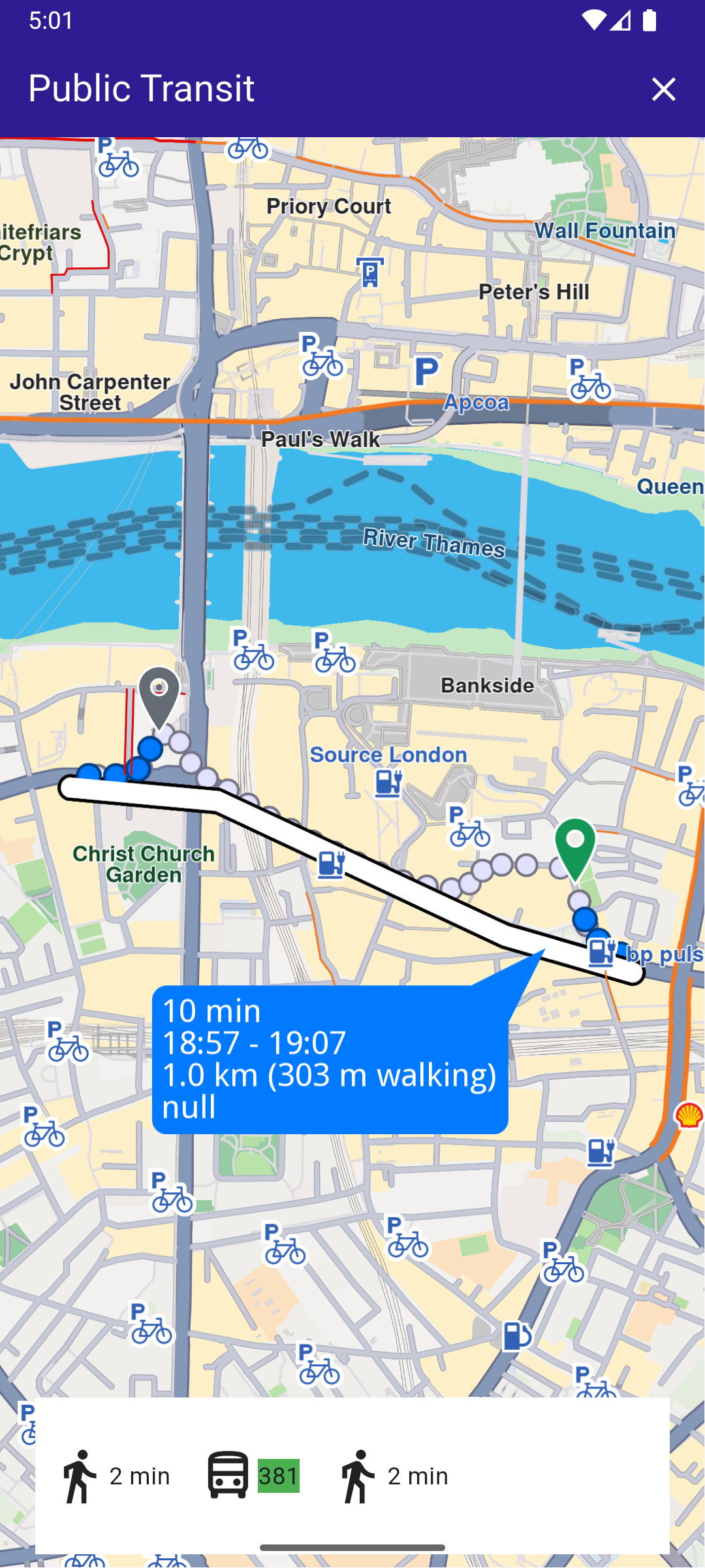
**Public Transit Route**
### UI and Map Integration[](#ui-and-map-integration "Direct link to UI and Map Integration")
This code sets up the main screen with a map and functionality for calculating and displaying public transit routes.
main.dart[View on Github](https://github.com/magiclane/magiclane-maps-sdk-examples-for-flutter/tree/main/public_transit/lib/main.dart?ref_type=heads#L13)
```dart
void main() {
runApp(const MyApp());
}
class MyApp extends StatelessWidget {
const MyApp({super.key});
@override
Widget build(BuildContext context) {
return const MaterialApp(
debugShowCheckedModeBanner: false,
title: 'Public Transit',
home: MyHomePage(),
);
}
}
class MyHomePage extends StatefulWidget {
const MyHomePage({super.key});
@override
State createState() => _MyHomePageState();
}
class _MyHomePageState extends State {
late GemMapController _mapController;
// We use the handler to cancel the route calculation.
TaskHandler? _routingHandler;
List? _ptSegments;
@override
void dispose() {
GemKit.release();
super.dispose();
}
@override
Widget build(BuildContext context) {
return Scaffold(
appBar: AppBar(
backgroundColor: Colors.deepPurple[900],
title: const Text(
'Public Transit',
style: TextStyle(color: Colors.white),
),
actions: [
// Routes are not built.
if (_routingHandler == null && _ptSegments == null)
IconButton(
onPressed: () => _onBuildRouteButtonPressed(context),
icon: const Icon(Icons.route, color: Colors.white),
),
// Routes calculating is in progress.
if (_routingHandler != null)
IconButton(
onPressed: () => _onCancelRouteButtonPressed(),
icon: const Icon(Icons.stop, color: Colors.white),
),
// Routes calculating is finished.
if (_ptSegments != null)
IconButton(
onPressed: () => _onClearRoutesButtonPressed(),
icon: const Icon(Icons.clear, color: Colors.white),
),
],
),
body: Stack(
alignment: AlignmentDirectional.bottomCenter,
children: [
GemMap(
key: ValueKey("GemMap"),
onMapCreated: _onMapCreated,
appAuthorization: projectApiToken,
),
if (_ptSegments != null)
Padding(
padding: const EdgeInsets.all(8.0),
child: Container(
height: MediaQuery.of(context).size.height * 0.1,
width: MediaQuery.of(context).size.width * 0.9,
color: Colors.white,
child: Row(
// Build a TransitSegment to display data from each segment
children: _ptSegments!.map((segment) {
return TransitSegment(segment: segment);
}).toList(),
),
),
),
],
),
);
}
// The callback for when map is ready to use.
Future _onMapCreated(GemMapController controller) async {
// Save controller for further usage.
_mapController = controller;
// Register route tap gesture callback.
await _registerRouteTapCallback();
}
```
### Route Calculation[](#route-calculation "Direct link to Route Calculation")
This code handles the route calculation and updates the UI with the calculated segments.
main.dart[View on Github](https://github.com/magiclane/magiclane-maps-sdk-examples-for-flutter/tree/main/public_transit/lib/main.dart?ref_type=heads#L118)
```dart
void _onBuildRouteButtonPressed(BuildContext context) {
// Define the departure.
final departureLandmark = Landmark.withLatLng(
latitude: 51.505929,
longitude: -0.097579,
);
// Define the destination.
final destinationLandmark = Landmark.withLatLng(
latitude: 51.507616,
longitude: -0.105036,
);
// Define the route preferences with public transport mode.
final routePreferences = RoutePreferences(
transportMode: RouteTransportMode.public,
);
_showSnackBar(context, message: "The route is being calculated.");
// Calling the calculateRoute SDK method.
// (err, results) - is a callback function that gets called when the route computing is finished.
// err is an error enum, results is a list of routes.
_routingHandler = RoutingService.calculateRoute(
[departureLandmark, destinationLandmark],
routePreferences,
(err, routes) {
// If the route calculation is finished, we don't have a progress listener anymore.
_routingHandler = null;
ScaffoldMessenger.of(context).clearSnackBars();
// If there aren't any errors, we display the routes.
if (err == GemError.success) {
// Get the routes collection from map preferences.
final routesMap = _mapController.preferences.routes;
// Display the routes on map.
for (final route in routes) {
routesMap.add(
route,
route == routes.first,
label: route == routes.first ? getMapLabel(route) : null,
);
}
// Center the camera on routes.
_mapController.centerOnRoutes(routes: routes);
// Convert normal route to PTRoute
final ptRoute = routes.first.toPTRoute();
// Convert each segment to PTRouteSegment
final List segments =
ptRoute!.segments.map((seg) => seg.toPTRouteSegment()).toList();
final List ptSegments = segments
.where((seg) => seg != null)
.cast()
.toList();
setState(() {
_ptSegments = ptSegments;
});
}
},
);
setState(() {});
}
```
### Transit Segment Display[](#transit-segment-display "Direct link to Transit Segment Display")
This widget displays transit segments and relevant information about each route leg.
main.dart[View on Github](https://github.com/magiclane/magiclane-maps-sdk-examples-for-flutter/tree/main/public_transit/lib/main.dart?ref_type=heads#L235)
```dart
class TransitSegment extends StatelessWidget {
final PTRouteSegment segment;
const TransitSegment({super.key, required this.segment});
@override
Widget build(BuildContext context) {
return Padding(
padding: const EdgeInsets.symmetric(horizontal: 8.0),
child: segment.transitType == TransitType.walk
? Row(
children: [
const Icon(Icons.directions_walk, size: 35.0),
Text(convertDistance(segment.timeDistance.totalDistanceM)),
],
)
: Row(
children: [
const Icon(Icons.directions_bus_outlined, size: 35.0),
if (segment.hasWheelchairSupport)
const Icon(Icons.accessible_forward),
Container(color: Colors.green, child: Text(segment.shortName)),
],
),
);
}
}
```
### Utility Functions[](#utility-functions "Direct link to Utility Functions")
These utility functions convert distances and durations into user-friendly formats.
utils.dart[View on Github](https://github.com/magiclane/magiclane-maps-sdk-examples-for-flutter/tree/main/public_transit/lib/utils.dart?ref_type=heads#L8)
```dart
String convertDistance(int meters) {
if (meters >= 1000) {
double kilometers = meters / 1000;
return '${kilometers.toStringAsFixed(1)} km';
} else {
return '${meters.toString()} m';
}
}
// Utility function to convert the seconds duration into a suitable format
String convertDuration(int seconds) {
int hours = seconds ~/ 3600;
int minutes = (seconds % 3600) ~/ 60;
int remainingSeconds = seconds % 60;
String hoursText = (hours > 0) ? '$hours h ' : '';
String minutesText = (minutes > 0) ? '$minutes min ' : '';
String secondsText =
(hours == 0 && minutes == 0) ? '$remainingSeconds sec' : '';
return (hoursText + minutesText + secondsText).trim();
```
### Displaying Route Information[](#displaying-route-information "Direct link to Displaying Route Information")
utils.dart[View on Github](https://github.com/magiclane/magiclane-maps-sdk-examples-for-flutter/tree/main/public_transit/lib/utils.dart?ref_type=heads#L31)
```dart
String getMapLabel(Route route) {
// Get total distance and total duration from time distance.
final totalDistance = route.getTimeDistance().unrestrictedDistanceM +
route.getTimeDistance().restrictedDistanceM;
final totalDuration = route.getTimeDistance().unrestrictedTimeS +
route.getTimeDistance().restrictedTimeS;
// Convert the route to a public transit route (PTRoute).
final publicTransitRoute = route.toPTRoute();
if (publicTransitRoute == null) {
return "";
}
// Get the first and last segments of the route.
final firstSegment = publicTransitRoute.segments.first.toPTRouteSegment();
final lastSegment = publicTransitRoute.segments.last.toPTRouteSegment();
if (firstSegment == null || lastSegment == null) {
return "";
}
// Get departure and arrival times from the segments.
final departureTime = firstSegment.departureTime;
final arrivalTime = lastSegment.arrivalTime;
// Calculate total walking distance (first and last segments are typically walking).
final totalWalkingDistance = firstSegment.timeDistance.totalDistanceM +
lastSegment.timeDistance.totalDistanceM;
String formattedDepartureTime = "";
String formattedArrivalTime = "";
if (departureTime != null && arrivalTime != null) {
// Format departure and arrival times.
formattedDepartureTime =
'${departureTime.hour}:${departureTime.minute.toString().padLeft(2, '0')}';
formattedArrivalTime =
'${arrivalTime.hour}:${arrivalTime.minute.toString().padLeft(2, '0')}';
}
// Build the label string with the route's details.
return '${convertDuration(totalDuration)}\n' // Total duration
'$formattedDepartureTime - $formattedArrivalTime\n' // Time range
'${convertDistance(totalDistance)} ' // Total distance
'(${convertDistance(totalWalkingDistance)} walking)\n' // Walking distance
'${publicTransitRoute.publicTransportFare ?? ""}'; // Fare
}
```